Citizen Investigation Coverage
:::note Reported claims, not proven facts Everything on this page is attributed citizen or social-media content unless a court or government source is cited. Citizen investigators are often first to point at an address; they are also often wrong. This log preserves the claims so they can be checked — it does not adopt them as findings. :::
@DiligentDenizen — "Command Center" video (Aug 9, 2026)
The most detailed citizen package aimed at this property is the 7:48 walkthrough posted by @DiligentDenizen, archived on IPFS for this site (see overview).
Claims in the post / narration (abridged):
- Vehicles (box truck + delivery truck + dumpster) formed a barricade blocking access the morning of 9/10.
- The property is the same place the "shooter" used to escape, per "eye witnesses" (unnamed).
- Same place a grey Challenger parked later that night, per Ring camera.
- Elevated ground with a clear view of the Losee Center roof and other UVU roofs.
- Narrator's conclusion: staging / "command center."
Independent geography check: the house is campus-edge (~0.25 mi), so the "across from Losee / up on a hill" framing is plausible, not absurd — but the video's exact building still needs Street-View / site match. Replies on the thread itself debate whether two houses in the video are the same structure.
Skepticism on X (same day): users mocked the idea that a "black ops" team would need a residential command center that close to campus when satellite and remote comms exist — e.g. @chrisG7676. Record both the claim and the pushback.
University ownership noticed on X
Within hours of the command-center video circulating, posters independently noted UVU ownership and urged satellite checks:
- @xcryptoace33 (Aug 9, 2026): "691 W 925 S St, Orem, UT 84058 - I'm pretty sure - the University Charlie was sacrificed - at owns it - check out satellite image of driveway on day if his death."
- @RBBL_ROUZR: speculative underground / excavation / trap-door theory tied to the house — no evidence presented; logged only as a theory circulating in the same address thread.
County records confirm UVU ownership (see deed chain); they do not confirm any black-ops use.
TikTok "vacant property linked to shooter" (Sept 2025)
@jessicadabit (about Sept 19, 2025) titled a video "Investigating Vacant Property Linked to Charlie Kirk Shooter" and named 691 W 925 S, Orem, describing it as vacant and a short distance from where the shooter descended from the UVU roof. That is citizen framing. No charging document reviewed for this page "links" the property to the charged suspect as a staging house. Vacancy itself, if true, would be a UVU-use fact worth confirming by GRAMA — not proof of guilt.
West 925 South in broader case discourse
Citizen case archives and X threads repeatedly name the street, not only 691:
- Grey Challenger on W 925 S ~00:30 on 9/11 — now aligned with court-cited Ring at 680 W 925 S (see block page).
- Timing debates about whether Robinson could have driven from southern Utah in time for that sighting (travel-time arithmetic on X; not settled here).
- Google Trends / "Israel searched W. 925 S Street" graphics posted by citizen accounts (e.g. threads amplified by @MadeYouThink12 / @baroncoleman materials) — treat as unauthenticated screenshots until raw Trends data is published.
- 683 W 925 S / Palantir confusion — largely debunked by LLC vs. hedge-fund distinction (block page).
- Construction-history posts noting Broderick & Howell registration at 691 in 1991 (@artisbrutal2021) — true as historical business-address color; not a 2025 operational link.
Mainstream coverage that touches the neighborhood (not the specific house)
Mainstream outlets covered the manhunt, Ring canvass, and Challenger without naming 691 as a staging house. Useful anchors:
- Fox 13 — ATF door-to-door canvass
- ABC4 — homeowner camera that caught the suspect
- Fox News Digital — ATF removes garage floodlight camera
- BBC — grey Challenger campus arrival 08:29
- Preliminary hearing coverage of 680 W 925 S Ring exhibits (Grabien archive)
Gap: mainstream naming of 691 as UVU property in 2019 exists in local board/news circulation; mainstream naming of 691 as a crime-related staging site has not been found in this research pass.
What citizen coverage has actually added
| Claim type | Value to investigation |
|---|---|
| Geolocation of a barricaded campus-edge house | High if building match is proven |
| UVU ownership call-out | Confirmed by county + board records |
| Nighttime Challenger "at the house" | Partial — court puts Challenger on the same street (680); 691-specific footage still unproduced here |
| Vacant / staging / underground theories | Unverified — generate GRAMA questions, not conclusions |
Open questions for the next research pass
- Archive every frame of the DiligentDenizen video against county GIS and Street View.
- Identify box truck / delivery truck logos or USDOT numbers from the barricade frames.
- Locate original Ring clip alleged for 691 (vs 680).
- Collect more geotagged Sept 10–11 posts from Instagram/TikTok/Nextdoor for this block.
Laws (Charlie Kirk)
Citizen video can start a lead; only compelled records finish it. See Records Requests and the Charlie Kirk Investigation Laws.
Interesting In This Area
- The staging claim is one sentence with no source, date or evidence.
- Court Ring video at 680 West 925 South is separate evidence entirely.
- UVU bought the house in 2019, which county records confirm.
- The mast at the construction site may be tactical hardware or a light tower.
Interesting In Other Areas
- A homeowner camera caught the figure walking toward campus before the shot.
- A Trends chart filtered to Israel spikes once for a neighboring address.
- Google Trends screenshots also circulate for two Utah judges, unauthenticated.
- Candace Owens amplified several of the same citizen threads to mainstream audiences.
Other Pages In This Section
Media Narratives and Censorship After the UVU Event
Two information environments formed after September 10: the wire-copy manhunt story, and a citizen ecosystem chasing the paving and the ballistics. The page maps where they split — including a witness who says the FBI asked him to delete his 4K footage.
Read thisThe RETCON13 Comms Mast at the Construction Site
A citizen investigator says the telescoping mast standing at the UVU construction site is hardware sold as a tactical vehicle communications antenna. A misidentified light tower would be nothing at all — the page lists exactly what would settle it.
Read this691 W 925 S — Prior Owners and Connected People
Broderick, Markides, Theobald — the people behind the deed chain, with status and public records for each. Every name appears because it sits on a deed or a tax roll, and none is connected to the case.
Read thisWest 925 South Block — Neighbors, Ring Video and Court Record
Court-admitted Ring video puts a grey Dodge Challenger parking at 680 W 925 S at about 00:30 on September 11. That is real evidence about the block — and it is not the same claim as the citizen footage said to show a car at 691.
Read thisElsewhere In The Investigation
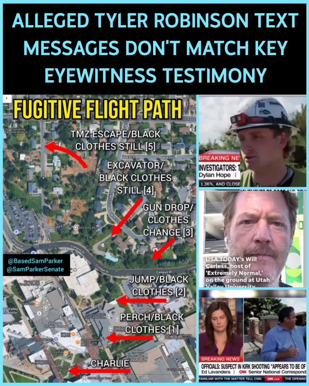
Black-Clad Fugitive Escape Path
An 11:47 reconstruction of every reported sighting of the all-black figure who left the Losee Center roof — dispatch audio, the crawl, the woods, and the residential streets north of campus.
Read this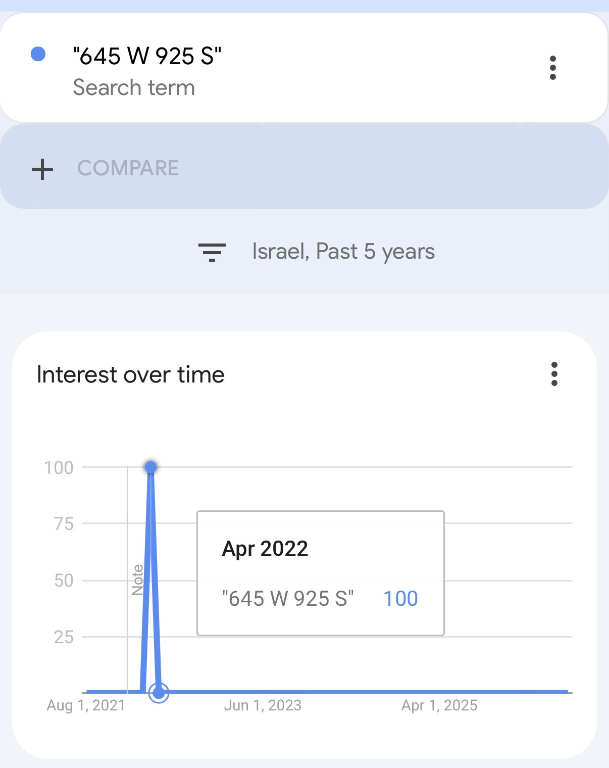
Israel Google Trends Spike for "645 W 925 S"
A Trends chart for one Orem address, filtered to Israel, is flat for five years except a single April 2022 spike. Two caveats land immediately: it is a different house on the same block, and Trends plots relative interest, not counts.
Read this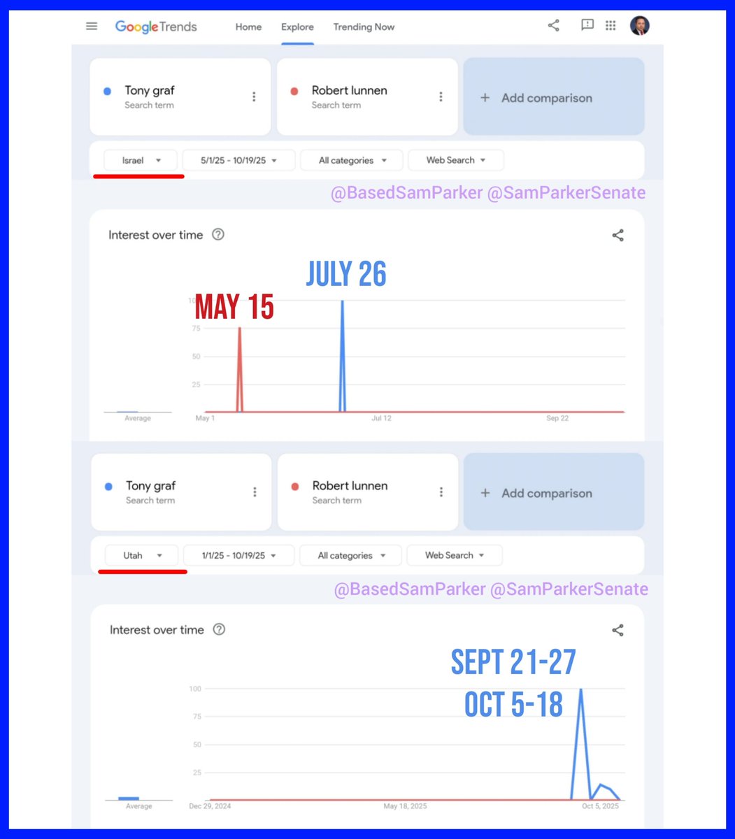
Judges Graf and Lunnen — Search Patterns
Claimed Google Trends activity from Israel for two Utah judges' names before Charlie Kirk was killed, with no Utah searches until afterwards. Screenshots, not raw data — treat it accordingly.
Read this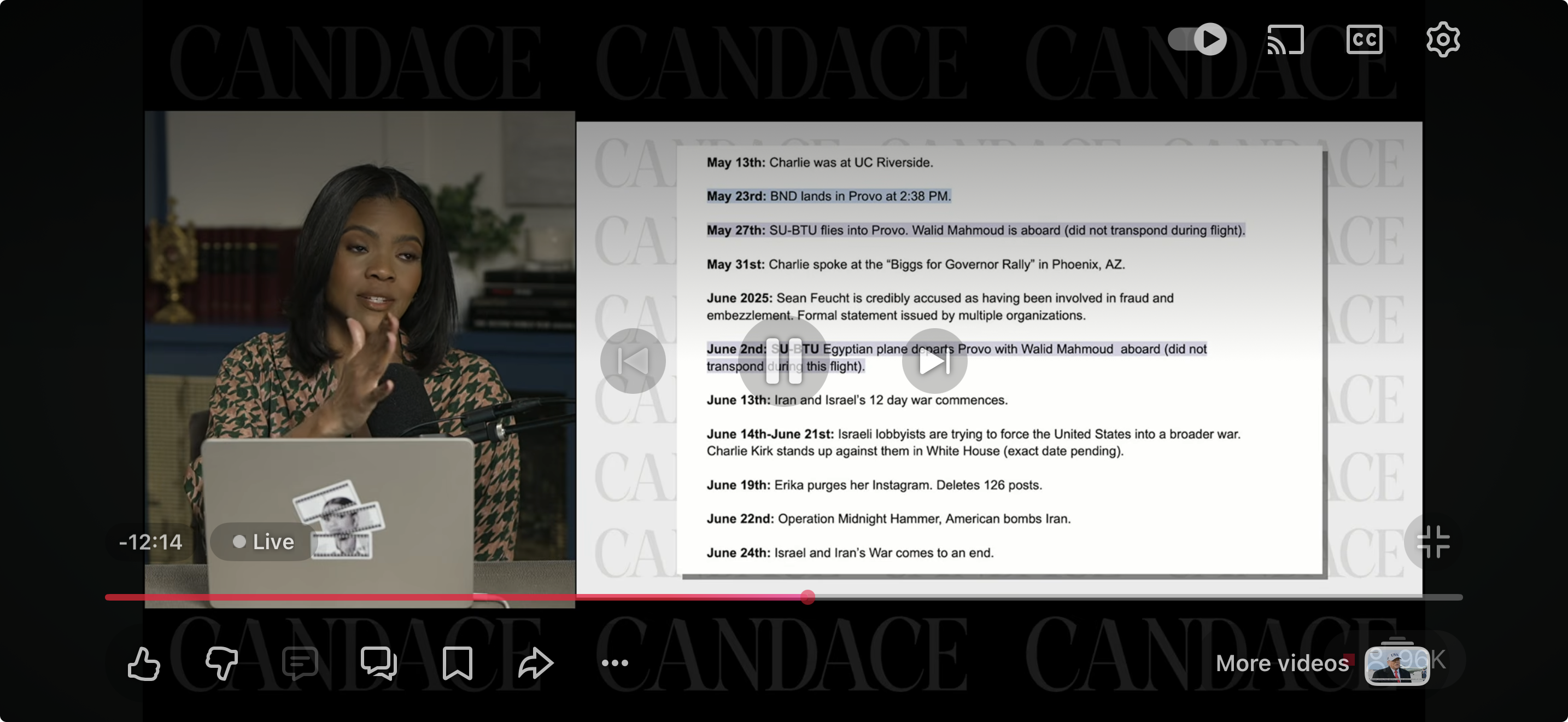
The podcaster who pushed hardest on the autopsy, the paving and the missing footage, and whose audience turned each of them into a mainstream news cycle.
Read thisThis website's author is @HolonCitizen on X and YouTube/@HolonCitizen. Follow me there.
Interesting
- A 1994 Air Force paper reportedly proposed pulsed energy to control emotions.
- The filing's Discord quotation is bracketed and elided — the public has seen photographs, not exports.
- Those confession posts reportedly appeared ninety minutes after Robinson was already in custody without phone access.