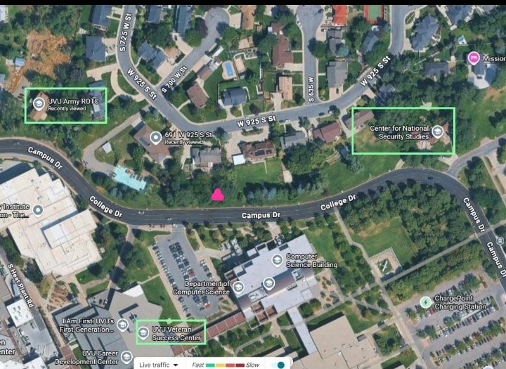
Map of Buildings Around the Gun Drop Area
 Next Image
What This Image Shows
An overhead satellite map of the campus edge and the residential neighbourhood beside it, with the street grid labelled — Campus Drive, College Drive, South 725 West, West 925 South, South 700 West, South 635 West, and South Heat Plant Road. Green boxes have been drawn around three named buildings: UVU Army ROTC, the Center for National Security Studies, and the UVU Veteran Success Center. Other campus points are labelled in passing, including the Computer Science Building and the Career Development Center.
The green boxes are the annotation and the argument. This image is used on Gun Dropped Location, which asks what sits on either side of the spot where the rifle was reportedly left, and the answer this map gives is that the route runs past an Army ROTC facility, a national security studies centre, and a veteran services centre.
The page it illustrates raises the questions that follow: according to a post by @MuppetMasher, the official statement puts the suspect's car in a campus lot at 8:29 AM but never states when he left it, and no cell-tower reconstruction of the walk has been released. Whether the neighbouring buildings mean anything or are simply what happens to be there is not established, and the map is offered as geography rather than as a conclusion. See also CIA and UVU Profiles, Gun Discovery Sequence, and the Walk Path imagery.
Where This Image Appears
This image is used on the following investigation pages:
- Gun Dropped Location
- Israel Needed Control Over College Campuses
- Cedar City Maverik Gas Station (I-15)
- Construction Site — 785 College Dr, Orem
- Img Gun Dropped RED 6f7c85
- overview
- UVU Campus Maps
Related Areas
- Cluster: Ballistics and the Gun
- Section: Gun & Bullet Analysis
- All photos: Photos
More In This Cluster
- Previous: Marked Detail Behind the Ear
- Next: Gun Cell