Annotated Movement Map With Hide Gun and Stairs
 Next Image
What This Image Shows
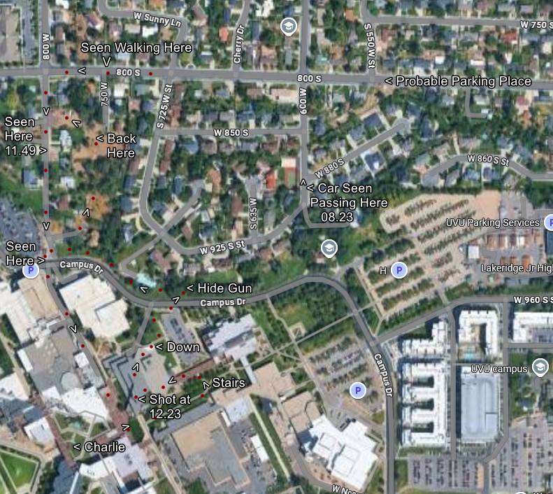
A satellite map covering the neighborhood streets above and the campus below, layered with red tracking dots, direction arrows and hand-added text tracing a movement account.
The labels read Seen Here 11.49, Seen Walking Here, Car Seen Passing Here 08.23, Probable Parking Place, Hide Gun, Down Stairs, Shot at 12.23 and Charlie, with street references including 800 S, Cherry Dr, W 850 S and Campus Dr. It is the same reconstruction family as the numbered route map in this cluster but built by a different researcher, which makes the two worth comparing directly. Every label is that researcher's inference from footage of varying quality; who the figure in that footage is remains contested, and no label here should be read as an established fact about anyone's movements.
Where independent reconstructions agree, the underlying footage is probably being read the same way by different people. Where they diverge - and the parking candidates and the descent route are the usual points of divergence - the disagreement marks exactly what the released material does not settle. The word probable on the parking label is the annotator's own hedge. Read it alongside the timed route map if you want the clock-time version, then Timeline, Gun Dropped Location and Proof It Was Not Tyler.
This website's author is @HolonCitizen on X and YouTube/@HolonCitizen. Follow me there.
Where This Image Appears
This image is used on the following investigation pages:
Related Areas
- Cluster: Maps and Site Geometry
- Section: Maps
- All photos: Photos