CBS News Five-Point Map of the Shooting
 Next Image
What This Image Shows
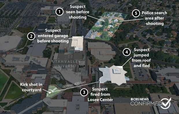
A news-organisation graphic built on angled satellite imagery of Utah Valley University in Orem, Utah, produced by CBS News and marked CONFIRMED. Five numbered markers, highlighted building zones and a dotted measurement line lay the sequence out across the campus and the adjacent neighborhood.
The marker text, quoting the graphic, reads: suspect seen before shooting; suspect entered garage before shooting; suspect fired from Losee Center; Kirk shot in courtyard; suspect jumped from roof and fled; and police search area after shooting. Those are CBS News's captions summarising the prosecution's account, not findings of this site; the charges against the accused are contested and have not been tried. This is the mainstream version of the movement account, published early and repeated widely, and it is included here precisely because it is the baseline the independent reconstructions in this cluster are arguing with.
The two things to check against it are distance and time. The dotted line gives the courtyard-to-Losee span that every acoustic argument depends on, and the marker order gives a sequence that the timed route maps later in this cluster attach clock times to. Where researchers have contested the account, it has generally been on whether the sound on the recordings is consistent with that distance, and on whether the roof-to-ground movement is physically achievable in the time available. See Maps, Losee Center, Impossible Timeline material in Proof It Was Not Tyler and Gun and Bullet.
This website's author is @HolonCitizen on X and YouTube/@HolonCitizen. Follow me there.
Where This Image Appears
This image is used on the following investigation pages:
- Img kirk shooting map8 939f1b x
- overview
- Img kirk shooting map8 939f1b
- overview
- overview
- The Gun Drop Location and the Search Sequence (Claims)
- Maps
Related Areas
- Cluster: Maps and Site Geometry
- Section: Maps
- All photos: Photos