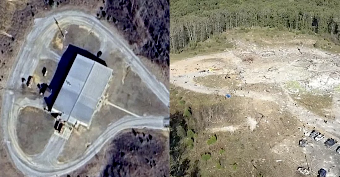
Before and After Aerial Comparison of the AES Building
 Next Image
What This Image Shows
A side-by-side comparison. The left panel is a crisp satellite overhead of the intact facility: a large rectangular building with a gabled light-grey metal roof, ringed by a looping asphalt access road with a single entry point on the right, with small outbuildings, storage tanks and utility poles alongside, surrounded by dry patchy grass and bordered by dense forest. The right panel is an oblique aerial photograph of the same site after the event: the building is entirely gone, replaced by a wide chaotic field of pulverized concrete, splintered wood, and twisted metal spilling outward across the landscape. The looping road is still partly traceable but cracked and debris-covered. A bright blue tarp or fragment lies near the center-left of the ruins, and a gravel parking area with vehicles is visible in the lower right.
The comparison is the clearest available record of the scale of the destruction: total structural loss rather than partial damage. That degree of destruction is what drew attention to the site, alongside the fact that the same building is named as the delivery address on the federal explosives purchase order held in this cluster.
An explosion of this magnitude at an explosives manufacturing plant has an obvious ordinary explanation, and no published investigation has tied this event to the Charlie Kirk case. The record is preserved because the coincidence of address and timing has been raised publicly, not because any connection has been shown. See AES — Explosion Factory and AES Tennessee Explosion.
This website's author is @HolonCitizen on X and YouTube/@HolonCitizen. Follow me there.
Where This Image Appears
This image is used on the following investigation pages:
- AES — Accurate Energetic Systems (Company Profile)
- AES — Accurate Energetic Systems Factory Explosion
- Microphone — The Exploding Mic Theory
- Img Before After 11db49
- overview
- overview
Related Areas
- Cluster: Accurate Energetic Systems
- All photos: Photos