Satellite Versus Drone: The Brown Patch Explained
 Next Image
What This Image Shows
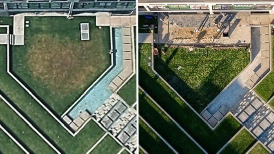
Two overhead views of the same geometric courtyard, placed side by side. The left is a satellite or high-altitude rendering showing what looks like a patch of browned, dying grass in the middle of a lawn bordered by a narrow water channel. The right is a high-resolution drone photograph of the same spot during active landscaping work, and it shows that the brown patch was a shadow cast by the building at that time of day.
This one is a correction, and it is worth keeping precisely because it corrects a claim rather than advancing one. A discoloured patch in satellite imagery had circulated as showing that something had been done to the ground; the drone frame shows the simpler explanation.
Keeping the debunk in the file alongside the claims is the standard this section should be judged by. The genuine site-alteration case does not depend on the satellite patch - it rests on the paving work, the accounts of the contractors, and the timeline. See Site Alteration and Paving Timeline September 14.
This website's author is @HolonCitizen on X and YouTube/@HolonCitizen. Follow me there.
Where This Image Appears
This image is used on the following investigation pages:
Related Areas
- Cluster: The UVU Venue
- Section: UVU
- Section: Campus & University
- All photos: Photos