Annotated Map of the 2021 Pipe Bomb Route
 Next Image
What This Image Shows
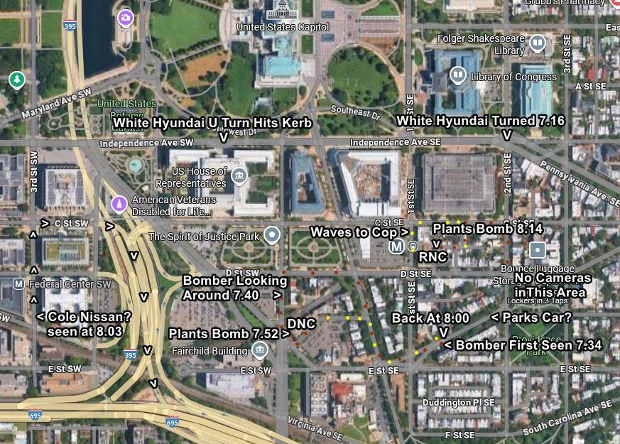
An annotated satellite map covering central Washington, D.C., from the United States Capitol south to Virginia Ave SE, with text overlays, arrows and colored dots plotting a timed route.
The annotations read: "White Hyundai Turned 7.16," "Bomber First Seen 7.34," "Bomber Looking Around 7.40," "Plants Bomb 7.52," near the DNC building; then "Back A: 8:00," "Cole Nissan? seen at 8.03," "Plants Bomb 8:14" near the RNC building; plus "White Hyundai U Turn hits Kerb," "Waves to Cop?," "Bounce luggage Stor No Cameras," "Lockers in 3 Taps" and "3 Parks Car?".
This concerns the still-unidentified person who placed pipe bombs at the two party headquarters in Washington on the night of January 5, 2021, not the events at Utah Valley University. It sits in this backlog because the analytical method is the same one applied throughout this archive: build a minute-by-minute route from surveillance frames, then ask which cameras should have covered the gaps and why nothing was produced from them. Every annotation is the mapmaker's reading. See Technology and Surveillance, FBI and Maps.
This website's author is @HolonCitizen on X and YouTube/@HolonCitizen. Follow me there.
Where This Image Appears
This image is used on the following investigation pages:
- Bomb Dogs Standdown
- Joshua_the_car — X Posts
- Img G9dVL NXgAAujSV b90230
- overview
- The Acoustics Point South, Not to Losee (Claims)
- Bomb Dogs Reportedly Kept From Parts of the Scene (Claims)
- The Acoustics Claim: Shot Came From the South (Claims)
Related Areas
- Cluster: Unfiled Backlog
- All photos: Photos
More In This Cluster
- Previous: Arizona Trade Name Filing for Firebird
- Next: Unfiled Backlog — Photo 51