AXEL21 Over St. George, September 11
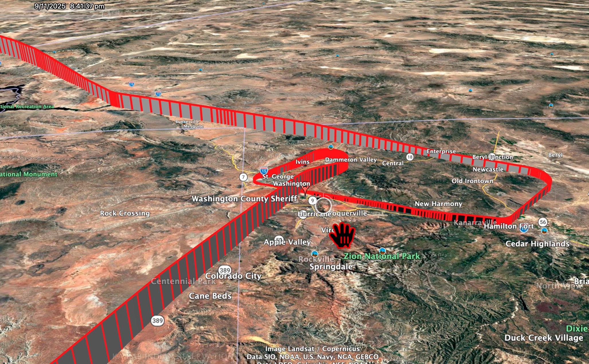
The AXEL21 track over southwest Utah, rendered in Google Earth and stamped 9/11/2025 8:41:37 pm. Posted by @I_Am_JohnCullen on X, 2 September 2026. Mirrored to IPFS by this investigation so it survives deletion.
On 2 September 2026, John Cullen posted a Google Earth render of an aircraft track over southwest Utah with the caption: "As Tyler Robinson was surrendering, at 9 pm at the Washington County Sheriff's station, near St. George, Utah.. ...HADES AXEL21 was doing this."
The track is real, and this site's own primary archives confirm it. The 9 PM surrender time in the caption is not. Tyler Robinson was in Washington County Sheriff's Office custody and had been read his rights at 6:25 PM that evening — or earlier — which is now in the court record. What was happening around 9 PM was two other things: this aircraft, and the Discord messages the state's narrative attributes to Robinson.
The correction: 6:25 PM, not 9 PM
Robinson surrendered at 6:25 PM on September 11, 2025, or before. The source is the court file, not a social-media claim: page 70 of a defense filing quotes discovery Bates 003996-R2 at timestamp 03:36:53, showing Miranda read at 06:25 PM and counsel invoked one minute later at 06:26 PM. A separate discovery index row — "Video at WCSO on 9/11/2025", Bates 3996-R1 — is the recording that timestamp comes from. The full documentation of that filing is on September 11 Turn-In Testimony, and the custody question is worked through on the 6:25 PM custody timeline and the Mirandize section.
The 9 PM figure is the federal framing, not the local record. It descends from the 33-hour manhunt number, which counted back from the shooting lands near 9:23 PM on September 11, and from surrender-arranging calls reported at 8:02 PM and 8:04 PM — hours after Robinson had already been Mirandized in the building the calls were supposedly arranging his arrival at. That conflict is laid out on Discord & Custody Timeline.
Cullen's picture does not need the 9 PM figure. Correcting it does not weaken the post — it sharpens it, because it separates three things that were all happening in the same two-hour window and were not the same event.
What 9 PM actually was
By 9 PM on September 11, 2025:
| Tyler Robinson | Already in WCSO custody roughly 2½ hours, Mirandized at 6:25 PM, counsel invoked at 6:26 PM, phone seized per county protocol |
| The Discord messages | Confession traffic from account zealous_monkey_55095 timestamped 7:57 PM, and continuing traffic through the evening |
| AXEL21 / N2100L | Flying the track in the picture — 8:28 PM to 9:15 PM MDT, over southwest Utah |
The Discord conversation was not written by Tyler Robinson. He had been in a sheriff's facility for hours by the time those messages posted, with his phone in custody. Whoever was typing from that account that evening, it was not the person the account is attributed to. This site does not name who it was — nobody has established that, and no forensic extraction of the seized electronics was offered at the preliminary stage. What is established is the exclusion: the timeline rules him out. See Discord Messages and Discord & Custody Timeline.
The plane is the part of Cullen's post that survives the correction intact, and it is the part worth the work.
The track, checked against primary data
This is not a case where a render has to be taken on trust. AXEL21 is the callsign this investigation already catalogues against tail N2100L — ICAO hex a1bbe5 — a Bombardier Global 6500 registered to LASAI Aviation II LLC, the fleet-mate of N1098L (callsign AXLE10), the HADES ISR jet that made the low passes near UVU on 10 September. This site holds recovered ADS-B traces for that hex on that date from two independent archives, adsb.lol and airplanes.live, pulled during the flight-data recovery effort.
Both archives carry the flight, and they agree to the second and to four decimal places of position. The render's burned-in timestamp lines up: at 8:41:37 PM MDT the traces put the aircraft at 37.60 N, 113.61 W at 13,050 ft, descending on a 030° track — the northeast lobe of the ribbon in the picture. The picture is a faithful playback of a real track.
What the aircraft actually did
The archives say something more specific than "was doing this", and it is worth stating precisely, because the specific version is stronger than the vague one.
| Time (MDT, 11 Sep 2025) | What the position data shows |
|---|---|
| 6:39 PM | Lands at Ontario, California (KONT), touching down on the runway centreline |
| 6:39 – 8:00 PM | On the ground at Ontario, about 80 minutes |
| 8:00 PM | Departs Ontario |
| 8:28 PM | Crossing into Nevada at 20,000 ft, tracking 030° — northeast, toward Utah |
| 8:41 PM | 37.60 N, 113.61 W at 13,050 ft — the render's timestamp |
| 8:45 – 8:53 PM | Turns back southwest and descends through the Cedar City corridor |
| 8:57 PM | Passing the Hurricane / Washington area at 5,575 ft, about 2,600 ft above the ground, at 127 knots, on a steady 210° line |
| 8:59 – 9:00 PM | Levels at 4,050 ft — 1,109 ft above the field — at 123 knots, tracking 201°, on the extended centreline of runway 19 |
| 9:00:45 PM | Goes around. Adds power and climbs away without landing |
| 9:00:53 PM | Crosses the runway 19 threshold at 0.08 km — directly overhead — already climbing through 4,325 ft |
| 9:07 PM | Passes back over the Hurricane area at 21,525 ft, climbing |
| 9:15 PM | Through 35,500 ft southeast-bound, accelerating away toward Arizona |
It flew one instrument approach to St. George Regional Airport at 9 PM, to about a thousand feet above the runway, and did not land. Closest approach to the airport reference point: 0.10 km. It then left to the southeast and was near Biggs Army Airfield, its home field, the following afternoon.
The detour is real, and it is large
Ontario, California to Biggs Army Airfield at El Paso is 1,075 km direct. Routed via St. George it is 1,368 km — 293 km and 27% further. St. George is not on the way to anywhere this aircraft went that night. The leg into southwest Utah was flown on purpose.
What this does not show, stated at the same size
The picture is a plane, not a purpose. A trace proves presence. It never proves intent, and it never proves occupancy — nobody has published a manifest for this leg, and nothing here places any person aboard.
"Orbit over the sheriff's station" is not what the data says. The tight turn near the placemark in the render is the descent and the go-around at the airport. The single closest pass to the Washington County Sheriff's Office and the Purgatory Correctional Facility complex is at 21,525 ft — four miles straight up, on the climb-out. The aircraft was low near the sheriff's office, at roughly 2,600 ft above ground, only on the way down the approach line, and that line goes to a runway. Reading the ribbon as a loiter over the jail is reading the graphic, not the numbers.
A single low approach at a quiet field at night is an ordinary thing for a crew to fly. Practice and currency approaches are routine, they are commonly flown at uncongested airports after dark, and a repositioning leg is exactly when a crew would fit one in. That explanation covers the go-around completely. What it covers less comfortably is the 293-kilometre detour to reach the field, and the date.
The distances to the sheriff's complex are approximate. The airport figures come from the OurAirports database this investigation already holds — KSGU at 37.036389 N, 113.510306 W, field elevation 2,941 ft, runway 19 threshold at 37.0481 N, 113.5041 W. The sheriff's-office figures use an approximate position for the Hurricane complex and are not sourced from a case document. Altitudes are barometric as transmitted, so the height-above-ground numbers carry the usual pressure-setting error.
Nothing here is an accusation against any person. Tyler Robinson is charged and is presumed innocent. The Discord finding on this page runs in his favour, not against him.
Why it matters anyway
Strip out the parts that do not hold and three things are left standing, all of them documented:
- Robinson was in custody and Mirandized at 6:25 PM, from the court file.
- The Discord "confession" posted at 7:57 PM and after, while he was in that building without his phone — so he did not write it.
- A HADES-fleet ISR jet flew 293 km out of its way to fly one approach to the St. George runway at 9 PM that same night, went around, and left.
Each of those is checkable independently. The middle one is the reason the case's central document is in question. The third is the one Cullen found, and it is the one that no amount of correcting his caption makes go away.