ISR Program Context
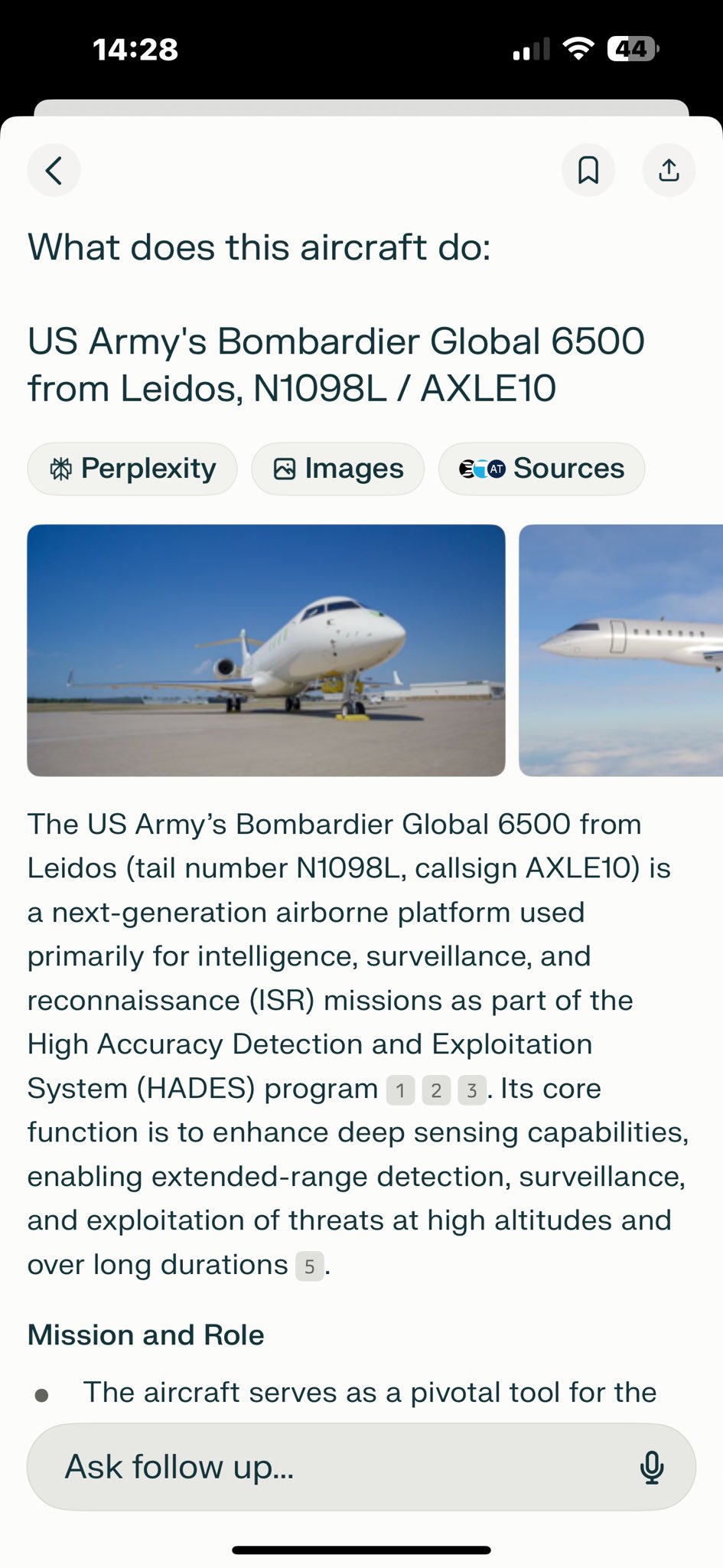
On 10 September 2025 a US Army ISR jet descended to 4,700 feet over Orem, Utah — 203 feet above the elevation of Provo Municipal Airport — at 114 knots, at 9:16:45 a.m. local. It came back over the same ground at 12:48:59 p.m., twenty-five minutes after Charlie Kirk was shot, and bottomed out at 4,750 feet. The aircraft was N1098L, callsign AXLE10, a Bombardier Global 6500 operated by LASAI Aviation II LLC under the Army's HADES program.
Those are not screenshots. They are primary ADS-B position points, recovered from two independent volunteer archives that agree with each other to the second and to within 0.1 km. For a year this page ended by asking someone to go pull that raw track. It has now been pulled, and the numbers are below.
What the recovered track actually shows
Both archives were queried for the same UTC day and the same ICAO hex (a0299e). airplanes.live returned 4,439 position points; adsb.lol returned 2,872. Every figure in this table appears in both files; where the two disagree at all, both values are shown.
| Pass | Time (UTC) | Time (MDT) | Lowest baro altitude | Above KPVU field elevation (4,497 ft) | Lowest groundspeed | Closest approach to UVU | Ground track |
|---|---|---|---|---|---|---|---|
| First | 15:16:45–15:16:48 | 9:16 a.m. | 4,700 ft | 203 ft | 114.3 kt | 4.16 km | 145.6° |
| Second | 18:48:59–18:49:03 | 12:48 p.m. | 4,750 ft | 253 ft | 123.1–123.7 kt | 4.16 km | — |
Charlie Kirk was shot at approximately 12:23 p.m. MDT. The second pass bottoms out 25 minutes later, over the same point on the ground — 40.238 N, 111.740 W, about 2.4 km northwest of the Provo Municipal runway complex and 4.7 km from the UVU campus.
Three things this settles, and they do not all cut the same way.
- The "203 feet" figure that circulates in this investigation is reproducible. 4,700 ft baro minus Provo's published 4,497 ft field elevation is exactly 203 feet. The arithmetic nobody had published is now checkable line by line.
- The 9:16 a.m. and 12:48 p.m. timings are confirmed to the second, from primary data, by two networks that do not share receivers. The @pennedpatriot Utah Lake reconstruction discussed below put the first descent at 9:15–9:17 a.m. That was right.
- "Loitering over Utah Lake near stall speed" is not what the track shows. The aircraft is descending on a steady 145.6° ground track at 114–121 knots. Provo's main runway 13/31 lies within a few degrees of that bearing. This profile is what a low approach to Provo Municipal looks like — approach speed, runway-aligned, levelling at a couple of hundred feet, then climbing away without touching down. It is also exactly what a deliberate low pass over the Orem corridor would look like. ADS-B cannot separate the two, and this page does not claim it can.
The rest of that day, hour by hour
The same recovered trace resolves N1098L's whole 10 September, and it confirms the reported schedule that until now rested on tracking-site screenshots.
| Time (UTC) | Time local | Where | Altitude | What it is |
|---|---|---|---|---|
| 01:16 | — | 47.835 N, 114.007 W (NW Montana) | 20,275 ft | First recovered position of the UTC day, already airborne |
| 03:37 | 9:37 p.m. MDT (9 Sep) | 31.886 N, 106.338 W | 4,550 ft | Arriving Biggs Army Airfield, El Paso |
| 03:37 → 13:48 | — | — | — | 10 h 11 min on the ground at Biggs — no positions recorded |
| 13:48 | 7:48 a.m. MDT | 31.861 N, 106.367 W | 4,850 ft | Departing Biggs — matching the 07:48 MDT departure this site has reported |
| 15:16 | 9:16 a.m. MDT | Over Orem / Provo | 4,700 ft | First low pass |
| 16:18 → 17:33 | — | Near Kalispell, MT | — | 75-minute coverage gap; the reported Glacier Park turnaround sits inside it |
| 18:48 | 12:48 p.m. MDT | Over Orem / Provo | 4,750 ft | Second low pass, 25 minutes after the shooting |
| 20:29 | 2:29 p.m. MDT | 31.861 N, 106.367 W | 3,825 ft | Back on the ground at Biggs |
| 21:15 | 3:15 p.m. MDT | 0.43 km from Biggs | 3,850 ft | Departing Biggs again |
| 23:42 | 4:42 p.m. PDT | 36.663 N, 121.617 W | 275 ft | Landing at Salinas, California |
The archives never actually see the aircraft on the ground at Glacier Park — it descends toward Kalispell, drops out of receiver coverage for 75 minutes, and reappears climbing away. That is a coverage gap, not a missing flight, and it is the ordinary shape of volunteer-network data over rural Montana.
How this was tested, and what would disprove it
Each pass was read straight out of the raw trace files rather than off a screenshot. The method, so anyone can repeat it:
- Query by ICAO hex, not by tail. N1098L is a0299e. That is the join key every ADS-B archive uses.
- Pull the same UTC day from two independent networks.
globe.airplanes.live/globe_history/2025/09/10/traces/9e/trace_full_a0299e.jsonandadsb.lol/globe_history/2025/09/10/traces/9e/trace_full_a0299e.json. Both returned HTTP 200. The stored copies and their retrieval metadata are insite/docs/Planes/N1098L/data/recovered/. - Compute distance to the campus and altitude above field elevation directly from the position rows. No interpolation, no smoothing.
- Require the two archives to agree before publishing a number. They agree on the minimum altitudes exactly, on the closest approach to 0.01 km, and on the timestamps to within four seconds.
What would disprove the surveillance reading: a Provo tower or approach-control tape showing N1098L on a published instrument approach to runway 13, or a LASAI/Army statement placing the aircraft on a training or currency sortie. Neither has been produced, and neither has been asked for on the record.
What would disprove the training reading: a tasking order, a sensor product, or a mission log for either pass. Also not produced. The flight profile alone cannot decide it, and this page will not pretend otherwise.
A trace proves presence, never purpose. No ADS-B record places any person aboard N1098L, names its crew, or says what — if anything — its sensors were doing. Everything below this line is the program context that a reader needs before deciding what the two passes mean.
What this page is
ISR — Intelligence, Surveillance, and Reconnaissance — is the umbrella term for military and contracted aviation missions that collect intelligence in real time over a target area. This page is the program-level hub for the aircraft in this section that are tied to active US Army ISR work — chiefly the LASAI Aviation fleet of Bombardier Global 6500 business jets flown under the Army's HADES program. Two of those tail numbers are catalogued individually: the N1098L spy plane, documented descending over the Orem / Utah Valley University corridor on September 10, 2025, and its fleet sister ship N2100L. Read this page first to understand what ISR capability is and why an Army-tasked ISR jet in the UVU airspace window matters; then read the two aircraft pages for the specific flight data.
What ISR aviation does
ISR-equipped aircraft typically combine some or all of the following capabilities:
- Signals intelligence (SIGINT): Intercepting radio, cellular, and other electronic emissions in the target area.
- Imagery intelligence (IMINT): Real-time electro-optical and infrared sensors with operator-grade resolution.
- Synthetic aperture radar (SAR): Through-cloud and through-foliage ground imaging.
- Drone deployment and recovery: Releasing and retrieving small unmanned systems for closer-in collection — a capability the Army has publicly said it wants to test from the Global 6500 HADES airframe (per The War Zone / TWZ reporting cited in the case notes).
- Communications relay: Acting as an airborne node for ground-team communications.
A platform with these sensors flying near an event does not, by itself, prove anything about that event. What it does establish is that records may exist — and that is the entire point of the questions below.
The HADES program
HADES — High Accuracy Detection & Exploitation System — is the US Army's planned ISR aircraft program-of-record built on the Bombardier Global 6500 airframe. It is intended to replace and consolidate several legacy ISR platforms (the Army's earlier ARTEMIS, ARES, and ATHENA prototype jets). According to the case notes, the HADES program is run out of Biggs Army Airfield (KBIF) in El Paso, Texas, and is associated with program lead Bradley Hansell.
The aircraft N1098L (ICAO hex A0299E, callsign AXLE10 — also rendered AXEL10 in some ADS-B logs) is publicly documented as part of this Global-6500 ISR ecosystem, operated by LASAI Aviation II LLC. Its fleet sister ship N2100L is named in the investigation as a "similar Global 6500" in the same LASAI reconnaissance fleet, tied in X analysis to the same AXLE-series effort and reported under callsigns AXLE21 / AXEL21. The whole LASAI Global 6500 fleet is described in citizen analysis as flying under a Leidos / LASAI "training" cover — the stated mission framing that the routine-vs-targeted debate below turns on. Both aircraft pages are being maintained in parallel:
- N1098L — HADES Spy Plane — the documented September 10 low-altitude passes near UVU.
- N2100L — LASAI Sister Ship — catalogued as a fleet-mate; not independently placed over UVU.
The contractor structure that limits public disclosure
Most US Army ISR missions are flown by defense contractors rather than uniformed military crews. Per the case notes and FAA records, LASAI Aviation II LLC is a defense contractor specializing in ISR missions for the US Army, registered at 10660 Aviation Lane, Manassas, VA 20110, and control of LASAI Aviation reportedly fell under Leidos in 2021. Industry reporting on the broader Army business-jet ISR competition has also named other large defense firms — among them Sierra Nevada Corporation and SAIC — as participants; the specific aircraft tracked in this case are the Leidos / LASAI Global 6500s.
The contracting structure means:
- Crew identities are typically protected as proprietary or classified.
- Mission tasking is typically not subject to public records requests.
- FAA-level flight tracking (ADS-B) is sometimes the only public visibility into the mission.
- Public NTSB databases will only show entries if there was an incident — and a search for N1098L returns no incidents.
This is why investigators of the September 10 N1098L flight have been unable to publicly confirm the crew or the tasking — the contracting layer is opaque by design. The case notes document that obtaining crew details would require formal FOIA requests to the FAA, direct requests to LASAI Aviation, or airport ramp-log requests at Biggs (KBIF) and Glacier Park (KGPI) — channels that are slow, often redacted, and rarely productive for a private observer. Two different and unverified crew lists for the September 10 flight have circulated on X, which underscores how little is actually confirmed.
Routine training vs. targeted surveillance — the open debate
Online discussion of the LASAI / HADES flights divides into two camps, and this page presents both even-handedly because neither is settled:
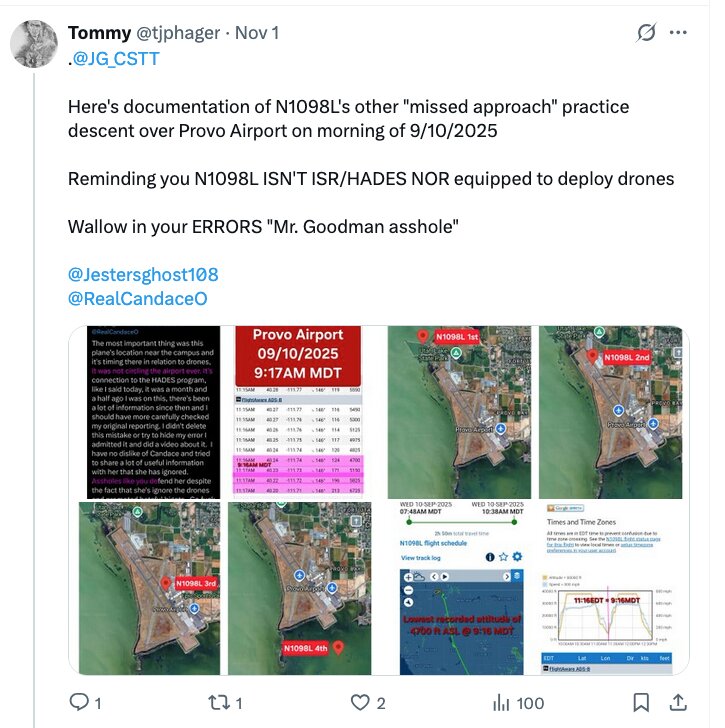
- Routine operations / training. On this reading, the September 10 flight profile was ordinary. One account framed N1098L's Orem low passes as drone drop-and-recovery training — describing two maneuvers (reported around 600 ft AGL and 335 ft AGL) as "textbook drone drop/recovery simulations." Skeptics in this camp, such as X user @TJPHager, have argued the aircraft was not built out to launch drones at all, which would weaken the surveillance reading entirely. This connects to a broader online dispute over whether the LASAI jets carry the full ME-11B sensor configuration: critics reportedly point out that the publicly visible equipment is interior-only, with no visible exterior modifications (radomes, antennas, or sensor blisters) of the kind a fully kitted-out ISR collection aircraft would normally show — an argument that, if correct, would cut against the most aggressive surveillance readings. Under this view, grouping N2100L with N1098L is guilt-by-fleet-association, not evidence.
- Targeted surveillance. Other citizen investigators on X — focused on the aircraft's surveillance capabilities, low-level operations, and possible real-time monitoring — argue that an Army ISR jet descending to low altitude near a campus hours before, and looping back after, a high-profile assassination is worth a full explanation regardless of the stated training purpose. The case notes also record that a contact at the National Counterterrorism Center (NCTC) said officials there were not aware of N1098L's flight path before or after the killing, and described the HADES plane's maneuvers as "too damning" when combined with the drone findings — an attributed, second-hand account, not a confirmed official finding. Some citizen theories in this camp have also raised Fort Huachuca — the US Army's intelligence base in southern Arizona — as a possible command or communications-relay node for the flights; this is presented as an online hypothesis, not an established fact.
Whether the September 10 profile reflects routine training or a targeted use of ISR assets has been debated extensively online and remains an open question, not a settled conclusion.
Why the September 10 ISR question matters
If a US Army ISR-tasked aircraft was operating in or near the UVU airspace at the time of the assassination, then the federal government has — at minimum — the possibility of sensor records of the area from an airborne platform. Whether those records exist, who has accessed them, and whether they have been preserved are questions that fall to congressional oversight, because the contractor structure puts them beyond ordinary public-records reach.
The same logic applies to any transponder-off segment of a foreign-government aircraft (see SU-BTT Israel/Egyptian Jet) or a private aircraft operating in the same airspace window.
Open questions
- Was N1098L tasked for ISR collection over UVU on September 10, or was the flight purely the repositioning / training run described in some accounts?
- If sensor or imagery records exist for that flight, who has accessed them, and have they been preserved under any litigation hold?
- Is N2100L actually ISR-equipped and was it airborne anywhere relevant on September 10–11, or is the "not equipped, not involved" view correct?
- How many Global 6500s does LASAI Aviation operate for the Army, and do they share crews, basing, or AXLE-series callsigns?
- Which congressional committee has jurisdiction to compel disclosure of HADES tasking and contractor records?
The primary published source on air-launched drones from a Global Express
The HADES air-launched-drone claim that circulates in this investigation is not invented. It traces to a specific, checkable trade article, and quoting it precisely separates what is documented from what is inferred.
The article is "Army Wants To Test Air-Launched Drones From A Global Express Business Jet," published by The War Zone (TWZ) under the section AIR / AIRBORNE SENSORS, by Thomas Newdick, published January 9, 2025, 4:03 PM EST (38 comments at capture). Its sub-headline:
The planned trials tally with previous comments about launching the drones from the new Global 6500-based HADES surveillance jet.
The article's lead image is a photograph of a matte-grey Bombardier Global Express in US Army markings, tail number 24001, with "US ARMY" on the rear upper fuselage. Visible modifications in the photograph: a large canoe-shaped fairing along the upper fuselage behind the cockpit, a large ventral radar fairing under the fuselage, and multiple blade antennas top and bottom. Landing gear extended, climbing against an overcast sky.
That establishes three things as documented fact rather than speculation:
- The US Army operates Global Express-family aircraft as ISR platforms, in Army markings, with externally visible sensor fairings.
- HADES is Global 6500-based, publicly acknowledged, and named in mainstream defence trade press.
- The Army has publicly stated an intent to test air-launched drones from this platform — as a planned trial, as of January 2025, eight months before the assassination.
What the article does not do is place any such aircraft anywhere near Utah, or establish that the drone-launch capability was fielded rather than merely planned. The gap between "the Army wants to test" and "it happened over Orem on September 10" is the entire distance the OSINT threads are trying to cover, and the article covers none of it.
The two Crowdsource The Truth posts that opened the ISR thread
@JG_CSTT (Crowdsource The Truth) posted the article on September 20, 2025, with this framing:
Maybe this is a coincidence but just last night [another account] and I were discussing the possibility of air launched drones at the Charlie Kirk assassination and this Bombardier HADES ISR jet was the exact platform we suspect they came from.
Note the honesty of the construction: "Maybe this is a coincidence" and "the platform we suspect." The poster is describing the article as matching a prior hypothesis, not as evidence for it.
The same post quotes an earlier one from the same account, seventeen hours before, which is the sharper question and the better one:
What was an ISR aircraft doing loitering over Utah Lake near stall speed in striking distance of Utah Valley University during the Charlie Kirk assassination?
"Loitering over Utah Lake near stall speed" is a specific, falsifiable assertion about a flight profile, and it is the claim that everything else on this thread hangs from. It is testable against the raw ADS-B archive: a large business jet flying near stall speed at low altitude over a lake would show a distinctive and unmistakable groundspeed and altitude signature. As of this writing, no one has published the raw track that would confirm or refute it — only annotated screenshots of it.
The @pennedpatriot Utah Lake telemetry claim
A separate post the same morning — @pennedpatriot, 9:43 AM, September 20, 2025, 211 views — attached a Google Earth 3D reconstruction of the Utah Valley looking west-southwest across Utah Lake, with an aircraft track overlaid as a chain of blue aircraft icons, each carrying its own UTC timestamp. The post text:
Drones drop from 650' above and into the water ~3 hours prior to the incident on the initial decent.
Drones are "picked up" from 300' above the water ~3 seconds after the incident on the second decent.
("decent" is written that way in the original.)
The timestamps legible on the reconstruction all carry the date 2025-09-10 and cluster in two groups:
- A dense, overlapping chain near the far shore — 15:06:05, 15:06:58, 15:07:04, 15:07:20 UTC, and later 15:22:54, 15:22:57, 15:23:55, 15:24:03 UTC.
- A spaced-out line running horizontally across the middle of Utah Lake — 15:15:08, 15:15:21, 15:15:34, 15:15:47, 15:16:01, 15:16:14, 15:16:28, 15:16:37, 15:16:44, 15:16:51 UTC.
A bright yellow vertical line is drawn dropping from the track down toward the ground near the Clarke Building on the UVU campus. Map labels visible on the reconstruction place the scene precisely: Utah Lake, Provo River Delta, Powell Slough Waterfowl Management Area, UVU Museum at Lakemount, Clarke Building, Westmore Elementary School, Orem Community Park, Lakeside Sports Park, Utah Lake State Park, with Lake Mountains HP and Mosida on the far ridge.
Converting the timestamps — and what they do and do not support
Utah was on Mountain Daylight Time (UTC−6) on September 10, 2025. Converting:
| UTC as shown | Utah local (MDT) |
|---|---|
| 15:06 – 15:07 | 9:06 – 9:07 a.m. |
| 15:15 – 15:17 | 9:15 – 9:17 a.m. |
| 15:22 – 15:24 | 9:22 – 9:24 a.m. |
Charlie Kirk was shot at approximately 12:23 p.m. MDT = 18:23 UTC.
Two conclusions follow, and they cut in opposite directions.
The first half of the claim is corroborated by an independent analyst. The 15:15 UTC group converts to 9:15 a.m. local — which is, to the minute, the time an independent flight-data analysis quoted on the SU-BTT page gives for the first of two low passes by AXL10, a Bombardier Global 6500 ISR aircraft, "about 3 hours before Charlie was shot." Two researchers working separately, one from a Google Earth track reconstruction and one from KML exports, put an aircraft over the same corridor at the same minute. That convergence is the strongest thing on this page. It also matches the post's own "~3 hours prior" framing: 9:15 a.m. to 12:23 p.m. is three hours and eight minutes.
The second half of the claim is not supported by the evidence in the post. Every timestamp visible on the reconstruction falls between 15:06 and 15:24 UTC — i.e. between 9:06 and 9:24 a.m. local. The post asserts a second descent and a drone "pick-up" "~3 seconds after the incident," which would be at approximately 18:23 UTC. No timestamp anywhere near 18:23 UTC appears in the image. Whatever supports the second-descent claim, it is not in the graphic offered as its evidence. The independent AXL10 analysis does place a second pass at 12:48 p.m. local (18:48 UTC) — twenty-five minutes after the shooting, not three seconds — which is a materially different claim.
The altitude figures are unsourced. "650 feet above and into the water" and "300 feet above the water" appear only in the post text. The reconstruction shows a track; it does not show altitudes. Note also that the AXL10 analysis derives its own low-altitude figure (~210 ft AGL) by subtracting terrain and lake elevation from barometric altitude — an arithmetic step that is highly sensitive to which elevation figure is used, and which no one has published the working for.
How to weigh it
This post is a useful lead and a poor proof, and both halves of that should be said plainly. The 9:15 a.m. corroboration is real and independently arrived at. The drone drop-and-recovery narrative built on top of it is not evidenced by anything in the material — it is an interpretation of what an aircraft flying low over a lake might have been doing, presented in the grammar of a finding.
The way to settle it is the same as everywhere else on this page: pull the raw ADS-B Exchange track for September 10, 2025 over the Utah Lake corridor and read the altitude and groundspeed columns directly. That is a few minutes of work for anyone with archive access, and it would either establish a genuinely extraordinary flight profile or close the question.
UPDATE — that track has now been pulled. The numbers are at the top of this page, and they split the post cleanly in two:
- Corroborated. The first descent is real, and its timing was right. The recovered trace bottoms out at 15:16:45 UTC = 9:16:45 a.m. MDT, inside the 15:15–15:17 UTC group the reconstruction shows. Both archives agree.
- Corroborated, and lower than claimed. The post's "650 feet above" is not what the data says. Minimum baro altitude on the first pass is 4,700 ft, which is 203 feet above Provo Municipal's field elevation, not 650.
- Still unsupported. The second descent is at 18:48:59 UTC = 12:48:59 p.m. MDT, twenty-five minutes after the shooting — not "~3 seconds after the incident." That was already the honest reading on this page and the primary data confirms it.
- Still unsupported, and now harder. Nothing in the position data speaks to drones. A descent and a climb are a descent and a climb. What the recovered track adds is that the profile is runway-aligned at approach speed, which is a reading the drop-and-recovery narrative has to account for and does not.
Related pages
Interesting In This Area
- N1098L and N2100L are the two catalogued LASAI airframes.
- Biggs Army Airfield is where the September 10 sortie began.
- Contractor structure keeps crew and tasking out of reach, unlike civil tails.
- Training or tasking is the open question the section index records.
Interesting In Other Areas
- US intelligence is the section that carries the agencies themselves.
- Military drones on video is a separate claim with separate footage.
- Technology and surveillance covers the sensors these aircraft carry.
- Intelligence services covers the foreign side of the same capability question.
Images



Other Pages In This Section
The Israel thread of the aircraft angle — jets that trackers say went dark over the eastern Mediterranean and reappeared on Israel legs. Parts of that routing are documented and parts are inferred, and the page marks which is which.
Read this
A Citation XLS that flew a short Scottsdale, Provo and Santa Barbara out-and-back on the morning of September 10, flagged on air by Candace Owens. The reported owner is described as a donor aviation entity; nothing beyond the route is established.
Read thisThe working memo for the aircraft angle — ISR passes, the Egyptian fleet, shadowing counts, SAM movements and transponder gaps, each with the record that would settle it. Start here if you want the questions rather than the tails.
Read thisThe fifth tail in the armada researchers count through Provo, and the one with the least written about it. Its weight comes entirely from the fleet pattern, not from any single documented event.
Read thisElsewhere In The Investigation

The domestic agencies — CIA, NSA, ODNI and NCTC, and defense intelligence — examined for what they collected and what they declined to pursue. The counterpart hub for non-U.S. services sits elsewhere on the site.
Read this
A 150 mph pass at fifty meters lasts under a second, which is why eyewitness drone counts run from zero to sixteen. The page separates streak claims on phone video from the one drone anybody admits flew.
Read this
Drones, surveillance systems and the technical evidence layer — what was watching that day, and what happened to what it recorded.
Read this
The non-U.S. services hub: foreign phones at the venue, Egyptian air-force tail numbers, search-pattern claims, and the blocked follow-up. Presence, motive and obstruction — not a courtroom finding.
Read thisSources
- The Defense Post, "US HADES spy plane" (Sept 10, 2025 coverage), and The War Zone / TWZ reporting on the Army's plan to test air-launched drones from a Global 6500-based HADES jet.
- Charlie Kirk investigation notes: N1098L identification (ICAO A0299E, callsign AXLE10), HADES program run out of Biggs Army Airfield, LASAI Aviation II LLC / Leidos contractor structure, and FOIA / operator contact channels.
- FAA registration and ADS-B data (Flightradar24 and ADS-B Exchange) for the LASAI Global 6500 fleet, including N1098L and N2100L.
- X / OSINT investigators on the ISR angle, including @TJPHager (skeptic, "not built to launch drones") — presented as competing, attributed views.
- Second-hand account attributed to a National Counterterrorism Center contact regarding awareness of N1098L's flight path.
Laws (Charlie Kirk)
- The HADES ISR sensor and imagery records for any flight over the UVU corridor on September 10, the classified contractor crew and Army tasking behind those flights, and the full LASAI Aviation fleet roster are exactly the kind of records the Charlie Kirk Investigation Laws are designed to force into the open — truths that the contractor structure currently keeps hidden.
Citizen Investigator Claims on X
(Aircraft OSINT and attributed claims — not findings that any pilot, passenger, or official ordered or carried out the assassination.)
- X users including @Josh89220 cite FAA/transponder logs of an Army HADES-class ISR jet (N1098L / AXLE10 in investigation notes) making low (~200 ft class) passes near UVU/Orem before and after the shooting — correlation claims, not proven operational role in the killing.
- Commentators ask whether ISR/counter-UAS capability at Provo/UVU that week was routine training or something investigators should subpoena — open question for N1098L and Counter-UAS.
- This page’s focus (ISR Program Context) should be read with the Planes overview and Sept 10 flight timeline for cross-checks.
This website's author is @HolonCitizen on X and YouTube/@HolonCitizen. Follow me there.
Interesting
- The low-pass aircraft launched from an Army airfield at Fort Bliss, not a civilian one.
- A filing puts the Miranda warning 90 minutes before the Discord confession.
- The defense roster includes death-penalty manual editors and Menendez retrial counsel.
Related Areas
Related
Track These Aircraft
This page describes an ISR program rather than one tail number. To research the aircraft tied to it, track the two LASAI Aviation Global 6500s on both major flight-tracking sites. FlightRadar24 honors the FAA's LADD block list (some flights can be hidden); ADS-B Exchange is volunteer-fed and unfiltered (it often shows blocked aircraft and tracks the filtered sites leave out).
- N1098L (callsign AXLE10) — FlightRadar24 · ADS-B Exchange
- N2100L — FlightRadar24 · ADS-B Exchange
Flight-record pages for what is on this page
This investigation keeps one page per airport and one page per recorded ground contact, built directly from the recovered ADS-B traces. These are the ones this page touches.
Ground contacts near a sourced Charlie / Erika / TPUSA event:
| Date (UTC) | Aircraft | Airport | City, State | Whose event | When |
|---|---|---|---|---|---|
| 2025-09-10 | N102DZ | KPVU | Provo, UT | Charlie | Same day |
| 2025-09-10 | N40JD | KPVU | Provo, UT | Charlie | Same day |
| 2025-09-10 | N560TW | KPVU | Provo, UT | Charlie | Same day |
| 2025-09-10 | N59906 | KPVU | Provo, UT | Charlie | Same day |
| 2025-09-10 | N872RA | KPVU | Provo, UT | Charlie | Same day |
| 2025-09-10 | N888KG | KPVU | Provo, UT | Charlie | Same day |
| 2025-09-10 | SU-BND | KPVU | Provo, UT | Charlie | Same day |
| 2025-09-10 | SU-BTT | KPVU | Provo, UT | Charlie | Same day |
Airports named on this page:
- KPVU — Provo Municipal Airport, Provo, UT — 135 recorded ground visits, 13 tracked aircraft
- KBIF — Biggs Army Air Field (Fort Bliss), Fort Bliss/El Paso, TX — 53 recorded ground visits, 2 tracked aircraft
- KGPI — Glacier Park International Airport, Kalispell, MT — 1 recorded ground visit, 1 tracked aircraft
Aircraft named on this page:
- N1098L — full recovered movement record, every airport and every leg
- N2100L — full recovered movement record, every airport and every leg
- N560TW — full recovered movement record, every airport and every leg
- SU-BGM — full recovered movement record, every airport and every leg
- SU-BTT — full recovered movement record, every airport and every leg
The two indexes:
- Every airport in this investigation — 292 fields, each with its complete recovered ground-visit and flight-leg record
- Every interesting date, all aircraft — 147 ground contacts near a sourced event, across 110 pages
- Investigating Deleted Flights — how the data was recovered, how much of it we hold, and where it is still missing
Where this page fits
Before you read what N1098L did on 10 September, this page tells you what the aircraft type is for — signals intelligence, imagery, synthetic aperture radar, drone launch and recovery — and which fleet and Army programme it belongs to, with the sister ship and the Army field it launched from catalogued separately. The capability is the point: an ISR platform near an event proves nothing about the event, but it does mean records exist — which is why the drone-count claims, the sixteen drones reported over campus, the campus and event camera threads and the reported halt of the FBI's foreign leads all end at the same closed door. For the specific numbers, go to N1098L Air-Launched Drones: a reported 203-foot pass at 9:16 AM and a return at 12:48 PM, twenty-five minutes after Kirk died, with no Army statement explaining either.