N59906 MARC Survey Plane
A Piper PA-31 Navajo Chieftain registered N59906, operated by aerial-survey contractor MARC Inc., is reported in public OSINT to have flown five mapping-style passes over and around the Utah Valley University campus on the morning of September 10, 2025, hours before Charlie Kirk was shot at roughly 12:23 p.m. MDT. Because the aircraft type is configured for high-resolution camera and LiDAR mapping, independent researchers flagged it as a possible aerial-surveillance flight rather than a drone. What it actually photographed — and who tasked it — remains unconfirmed.
This page is about tail N59906 (MARC Inc. survey aircraft). Do not confuse it with the separately discussed tail N55906, a different aircraft raised in independent-investigator analysis. The two tail numbers differ by one digit and are easy to transpose.
Aircraft identification
- Tail number: N59906
- Type: Piper PA-31 Navajo Chieftain
- Operator / owner: MARC Inc. — described in OSINT reporting as North America's largest provider of specialized contract aircraft for airborne GIS, geophysical surveys, mapping, and surveillance projects
- Base of operation that day: Provo Municipal Airport (PVU), about 4 miles south of the UVU campus
- Mission profile: contract aerial survey / mapping; not a scheduled or military flight
Flight history relevant to the case
According to OSINT analysis attributed to researcher @rosenwald_eric and circulated by independent investigators, on the morning of September 10, 2025 the aircraft made five passes that originated and ended at Provo Airport, flying at roughly 19,000 feet MSL — about 15,000 feet above ground level given Provo's elevation. That is a standard high-altitude aerial-mapping band, not a treetop pass; the "low-altitude" label used in some early posts is misleading, and the figures are reproduced here as reported.
| Pass | Time (MDT) | Duration | Note |
|---|---|---|---|
| 1 | 11:01 a.m. | ~5 min | First north-south pass over central campus |
| 2 | 11:09 a.m. | ~4 min | Second pass, offset slightly eastward |
| 3 | 11:18 a.m. | ~5 min | Third pass, reportedly focused on the event area |
| 4 | 11:26 a.m. | ~5 min | Fourth pass — see the correction note below |
| 5 | 11:35 a.m. | ~6 min | Final pass; alleged shooter reportedly first seen on campus surveillance at 11:50 a.m. |
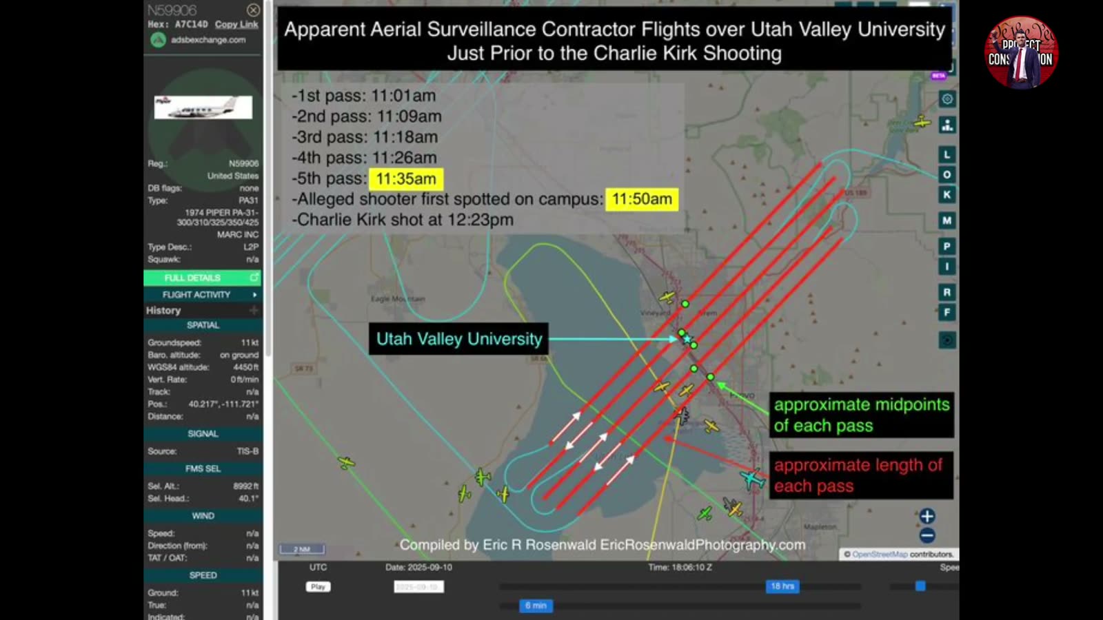
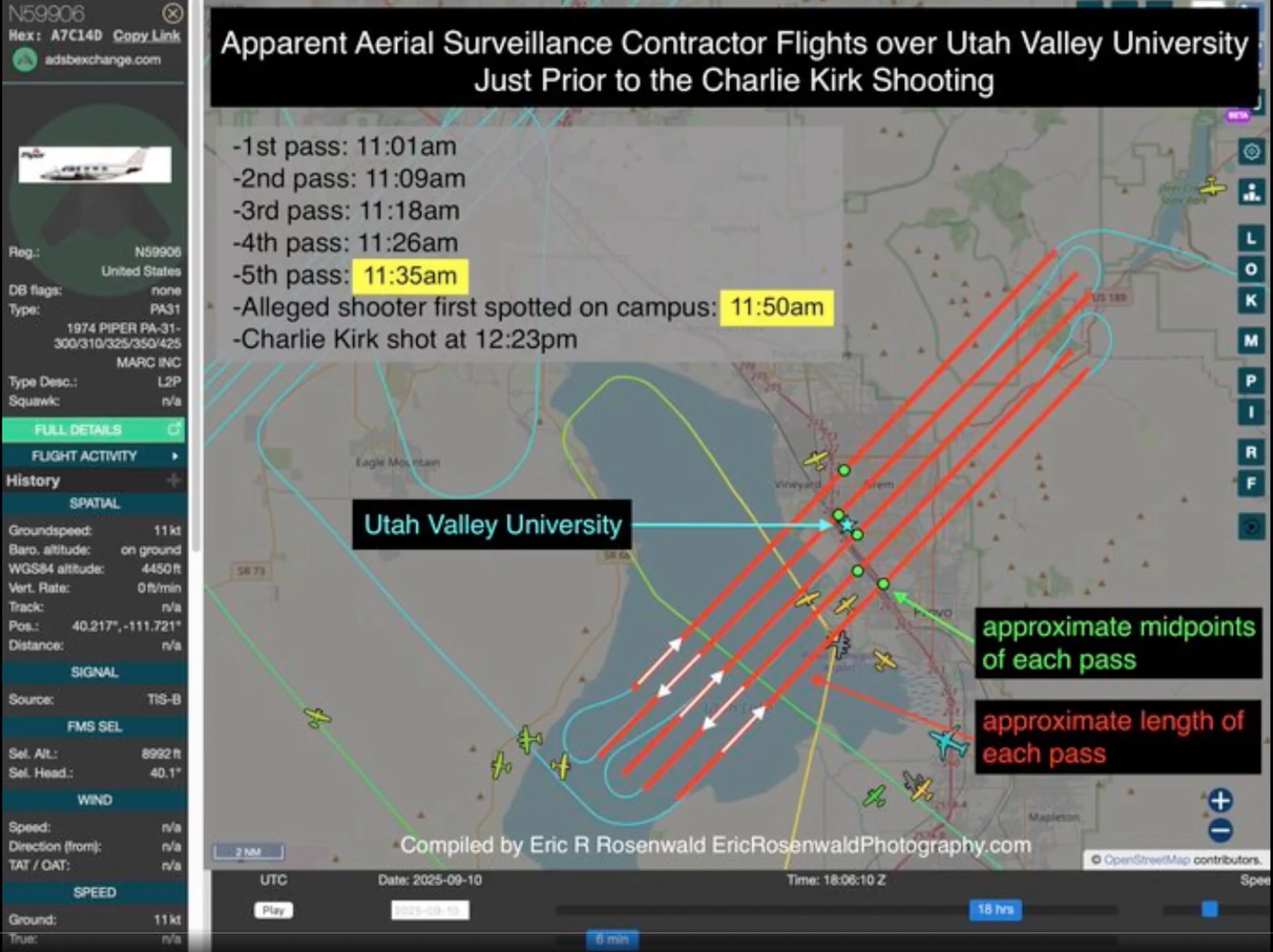
Correction — there are five passes, not four. Earlier versions of this page listed four, omitting the 11:26 a.m. pass. The annotated adsbexchange graphic compiled by Eric R Rosenwald (EricRosenwaldPhotography.com), captured at 2025-09-10 18:06:10 Z, lists the passes explicitly and there are five of them:
"Apparent Aerial Surveillance Contractor Flights over Utah Valley University Just Prior to the Charlie Kirk Shooting — 1st pass: 11:01 am · 2nd pass: 11:09 am · 3rd pass: 11:18 am · 4th pass: 11:26 am · 5th pass: 11:35 am · Alleged shooter first spotted on campus: 11:50 am · Charlie Kirk shot at 12:23 pm"
The five passes are spaced eight to nine minutes apart across a 34-minute block, which is what a programmed survey grid looks like: parallel lines flown at a constant interval so the imagery overlaps. The graphic marks the approximate midpoint and approximate length of each pass. That regularity is the point in both directions — it is the signature of an automated mapping run, which is also the innocent explanation, and it is not what an aircraft loitering to watch a specific thing would fly.
The same graphic records the aircraft's identity from adsbexchange: hex A7C14D, a 1974 Piper PA-31-300/310/325/350/425, type code PA31, registered to MARC INC, with the ADS-B position source shown as TIS-B rather than a direct ADS-B Out return.
The reporting states that open-source ADS-B flight tracking confirmed this pass pattern. One early post mislabeled the flight date as "Sep 15," but the same post places the passes "hours before" the September 10 attack; the September 10 morning timing is what the pass-by-pass log describes.
N59906 also appears in the broader "anomalous aircraft near UVU / Utah corridor" catalogs that independent investigators have assembled — informal lists cross-referencing aircraft reportedly operating around the campus and the surrounding Utah airspace in the hours and days around the event. Its inclusion there is reported as a flagged data point for follow-up, not as proof of any coordinated activity.
Survey and surveillance payload
Public reporting describes MARC Inc.'s survey aircraft as equipped for high-resolution data capture. The payloads below are described in general for the operator's fleet; it is not independently confirmed which specific sensors were aboard N59906 on September 10.
- Cameras: Vexcel large-format digital, Leica, hyperspectral, and infrared scanners.
- LiDAR: Optech Orion / Gemini / 3100 systems for 3D mapping.
- Storage: Onboard data systems for multispectral and hyperspectral imaging.
MARC Inc. is reported to serve U.S. federal and state governments, foreign entities, private mapping firms, oil and gas companies, civil-engineering groups, and universities — applications ranging from aerial photography and geophysical surveys to pipeline monitoring and surveillance. Neither MARC Inc. nor the FBI has publicly confirmed the flight's purpose or client, and the airspace over the event reportedly remained unrestricted, which some commenters criticized given the timing.
Alleged leaked imagery
Public reporting states that on October 13, 2025, a TikTok account (@universehop00) posted images claimed to originate from the N59906 flight — reportedly one day after the same account's first post on the topic. The account is said to have had no other content, which some commenters read as a sign of a targeted leak from a contractor or insider. The images are described as high-resolution orthomosaic views of the UVU quad and stage area, with metadata said to align with the 11:35 a.m. pass, and one post alleged a figure near a rooftop access point about 45 minutes before the shooting. These images are unverified. Their authenticity, source, and metadata have not been independently confirmed, and they should be treated as an unproven claim rather than evidence.
The Alpha Whiskey / Alexis Wilkins allegation (unproven)
A separate and far more contested claim circulated on X tied N59906's operator to a company linked to Alexis Wilkins, a country singer who is publicly reported to be the girlfriend of Kash Patel, the current FBI Director. This section sets out the claim as it was posted and then the rebuttal. None of the connection alleged below has been confirmed; it is an unproven allegation amplified on social media and is reproduced here only to document and assess it.
What the X accounts alleged
A thread shared by accounts including @ProjectConstitu, @AnaEscobarShow, @leahfiles, @Mini_111111, and @StefaniWilcox8 carried the headline claim, quoted here verbatim:
"BOMBSHELL: The MARC INC Plane That Was Circling UVU Taking SURVEILLANCE Pictures During The Charlie Kirk Event Is Tied to a Company Where Kash Patel's GIRLFRIEND Alexis Wilkins Is the Registered Agent?"
The posts laid out the following alleged ownership chain:
- A pending registration reportedly names Alpha Whiskey 2 LLC in Brandon, Mississippi in connection with the aircraft's ownership/operation.
- A separately named entity, Alpha Whiskey Inc (Tennessee, reportedly active since 2020), is said to list Alexis Wilkins as registered agent/principal, based in Nashville.
- The posts note that "Kash Patel is currently the Director of the FBI," and frame the shared "Alpha Whiskey" name plus the timing of the flight as evidence of an intelligence connection — "The intelligence connections are impossible to ignore."
The accounts used these claims to push for legislation forcing disclosure of MARC Inc.'s flight records, who hired the aircraft, the passengers and crew aboard, and any transponder deactivation.
The rebuttal — what the evidence actually shows
The allegation rests on a name similarity plus timing, and the rebuttal to it is prominent and substantive. Responses in the same threads (including from Grok) and from other commenters made the following points:
- No public evidence links the two LLCs — or Alexis Wilkins or Kash Patel — to the flight, to MARC Inc., or to the Charlie Kirk event.
- The inference is speculation drawn from a shared company name and the timing of the flight, not from any documented relationship.
- High-resolution LiDAR and aerial-survey work is standard for the kind of contractor MARC Inc. is, so the aircraft's capabilities are not by themselves anomalous.
- There are no confirmed shared ownership, officers, communications, financial, or operational links between the entities or the people named.
Because Alexis Wilkins and Kash Patel are living people, no statement here should be read as asserting that either is connected to the aircraft, the flight, or the assassination. They are not. The claim is an allegation made on social media, it is disputed in the same threads where it appeared, and as of now it is unproven.
Theories about the aircraft's role
These are open theories raised by independent investigators, not established facts:
- Routine survey work. Provo sits on the Interstate-15 corridor, and survey contractors regularly fly mapping grids for infrastructure, utility, and engineering clients. Under this reading the timing is coincidental, and any imagery — if it exists — would simply document the area, per @rosenwald_eric's own framing that the photos could "debunk conspiracies."
- Tasked pre-event imaging. Other commenters argue the four-pass pattern in the two hours before the attack, by a contractor that lists "surveillance" among its services, is suspicious and worth subpoenaing. Under this reading the flight may have captured the stage area, rooftops, and approaches before the shooting.
- Evidence-capture, intent unknown. A middle position: the aircraft plausibly recorded high-resolution imagery of the campus that morning regardless of who tasked it, making the existence, custody, and content of that data the central question — whether it helps the Tyler Robinson case or points elsewhere.
No theory here asserts criminal conduct by any named person or by MARC Inc. The operator's purpose and client remain officially unconfirmed.
Open questions
- Who contracted and paid for the N59906 flight on the morning of September 10, 2025?
- Which specific sensors were aboard N59906 that day, and was imagery delivered to the customer in real time or after the fact?
- Did the survey passes capture the event area, the stage, and the rooftops before the shooting, and where is that data now?
- Was this routine infrastructure survey work (e.g., the nearby Interstate-15 corridor) or task-specific imaging tied to the event?
- Are the alleged leaked TikTok images authentic, and if so, who released them and from what source?
- Why did airspace over the venue remain unrestricted despite a high-profile public event?
The primary ADS-B Exchange record card
The most-circulated N59906 artifact is a single annotated screen capture of ADS-B Exchange, stamped Date: 2025-09-10, Time: 18:06:10 Z and credited in a caption line along the bottom of the image to "Compiled by Eric R Rosenwald — EricRosenwaldPhotography.com." That capture is the origin of nearly every downstream post about this aircraft, so its own contents are worth reading directly rather than through summaries. The tracker's left-hand data panel, transcribed from the image, reads:
| Field | Value as displayed |
|---|---|
| Registration | N59906 |
| Mode S / ICAO hex | A7C14D |
| DB flags | none |
| Type | PA31 |
| Type description | L2P (land, 2 engines, piston) |
| Full type | 1974 PIPER PA-31-300/310/325/350/425 |
| Operator | MARC INC |
| Country | United States |
| Squawk | n/a |
| Groundspeed | 11 kt |
| Barometric altitude | on ground |
| WGS84 altitude | 4,450 ft |
| Vertical rate | 0 ft/min |
| Position | 40.217°, −111.721° |
| Data source | TIS-B |
| Selected altitude (FMS) | 8,992 ft |
| Selected heading (FMS) | 40.1° |
Three details in that panel are worth pulling out, because they are checkable and they are not in the summaries:
- The build year is 1974. This is a fifty-one-year-old piston twin, not a modern turbine ISR platform. That cuts against the more dramatic readings of the flight and toward the survey-contractor reading.
- The position 40.217°, −111.721° is the Provo Municipal Airport ramp, and the capture shows the aircraft on the ground at 11 knots — i.e. taxiing — at the moment the screenshot was taken. The annotated flight track on the map is playback history, not a live position.
- The data source is TIS-B, not ADS-B. TIS-B (Traffic Information Service-Broadcast) is a ground-station rebroadcast of radar-derived tracks rather than the aircraft's own ADS-B Out. TIS-B positions are lower-fidelity and can lag, drop, or snap. Anyone attempting to re-derive the pass geometry or altitudes from this capture should account for that; it is one reason the altitude figures on this page are given as reported rather than as measured.
Five passes, not four — and the timeline printed on the graphic
The annotated map carries its own timeline in white text in the upper-left of the frame. It lists five passes, not the four described in earlier posts, and it interleaves them with two case anchors:
| Line as printed on the graphic | Time |
|---|---|
| 1st pass | 11:01 am |
| 2nd pass | 11:09 am |
| 3rd pass | 11:18 am |
| 4th pass | 11:26 am |
| 5th pass (highlighted yellow on the graphic) | 11:35 am |
| Alleged shooter first spotted on campus (highlighted yellow) | 11:50 am |
| Charlie Kirk shot | 12:23 pm |
The 11:26 a.m. fourth pass is missing from the four-row version of this table circulating elsewhere; the compiler's own graphic lists it, and the pass log higher on this page has been corrected to five rows to match. The passes are spaced 8, 9, 8 and 9 minutes apart — a metronomic interval, which is exactly what a survey aircraft flying a photogrammetric grid produces and also exactly what a loiter orbit produces. The interval alone distinguishes nothing.
Two further annotations appear on the map itself: a green dotted line labelled "approximate midpoints of each pass" and red bars labelled "approximate length of each pass." Both are the compiler's own reconstruction, drawn on top of the track, not values the tracker output. The five red bars run southwest to northeast with arrows alternating direction — a back-and-forth boustrophedon, the standard mapping pattern. A light-blue star marks Utah Valley University beside the track.
Note also that the compiler chose to highlight the 5th pass and the shooter-sighting line in yellow — a visual pairing that invites the reader to connect them. The 11:35 pass and the 11:50 sighting are 15 minutes apart, and nothing on the graphic establishes any relationship between them beyond adjacency in time.
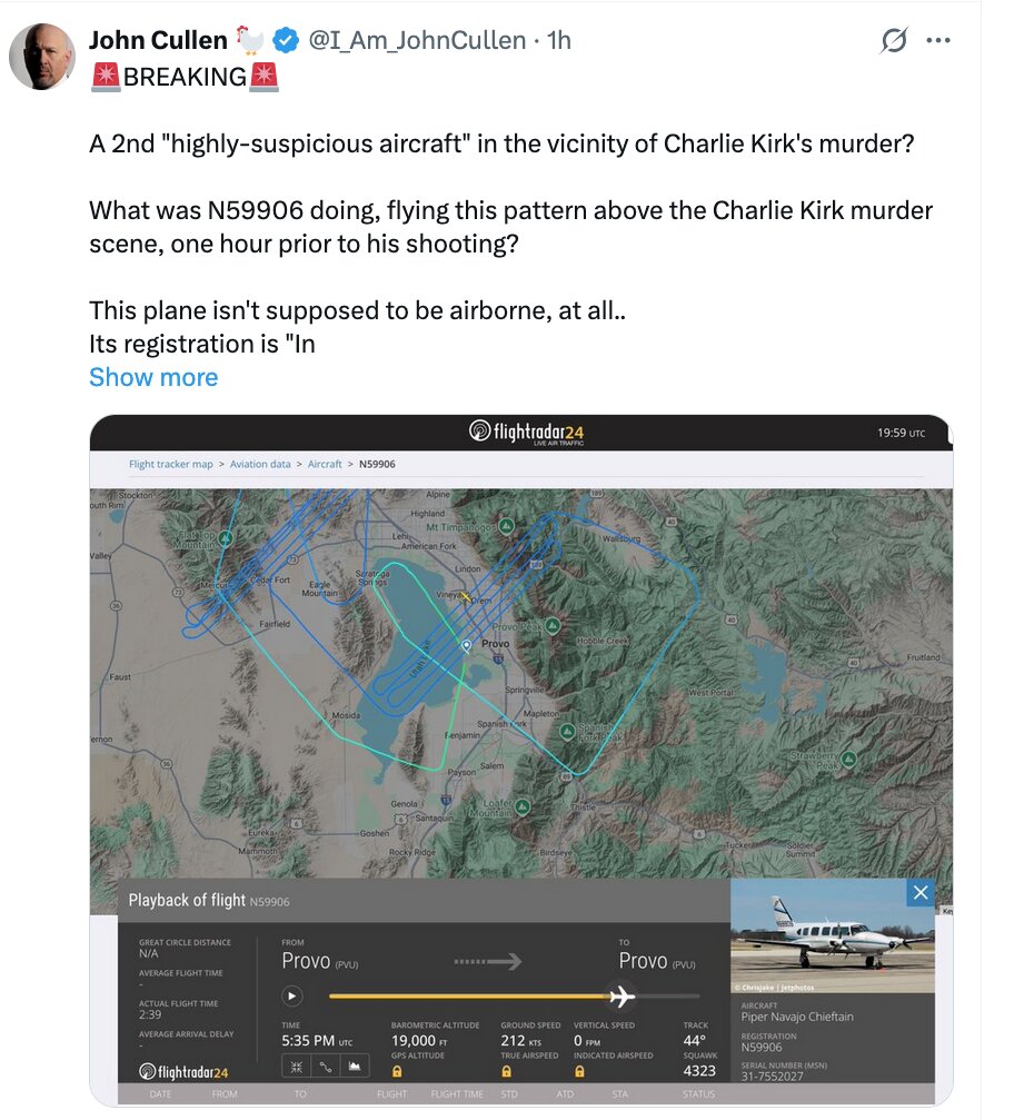
The Flightradar24 playback card
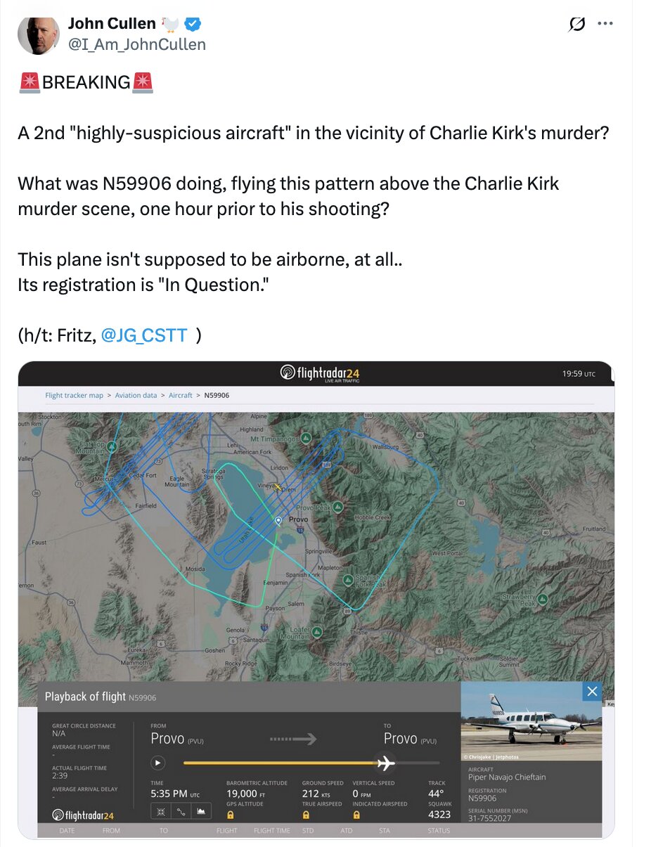
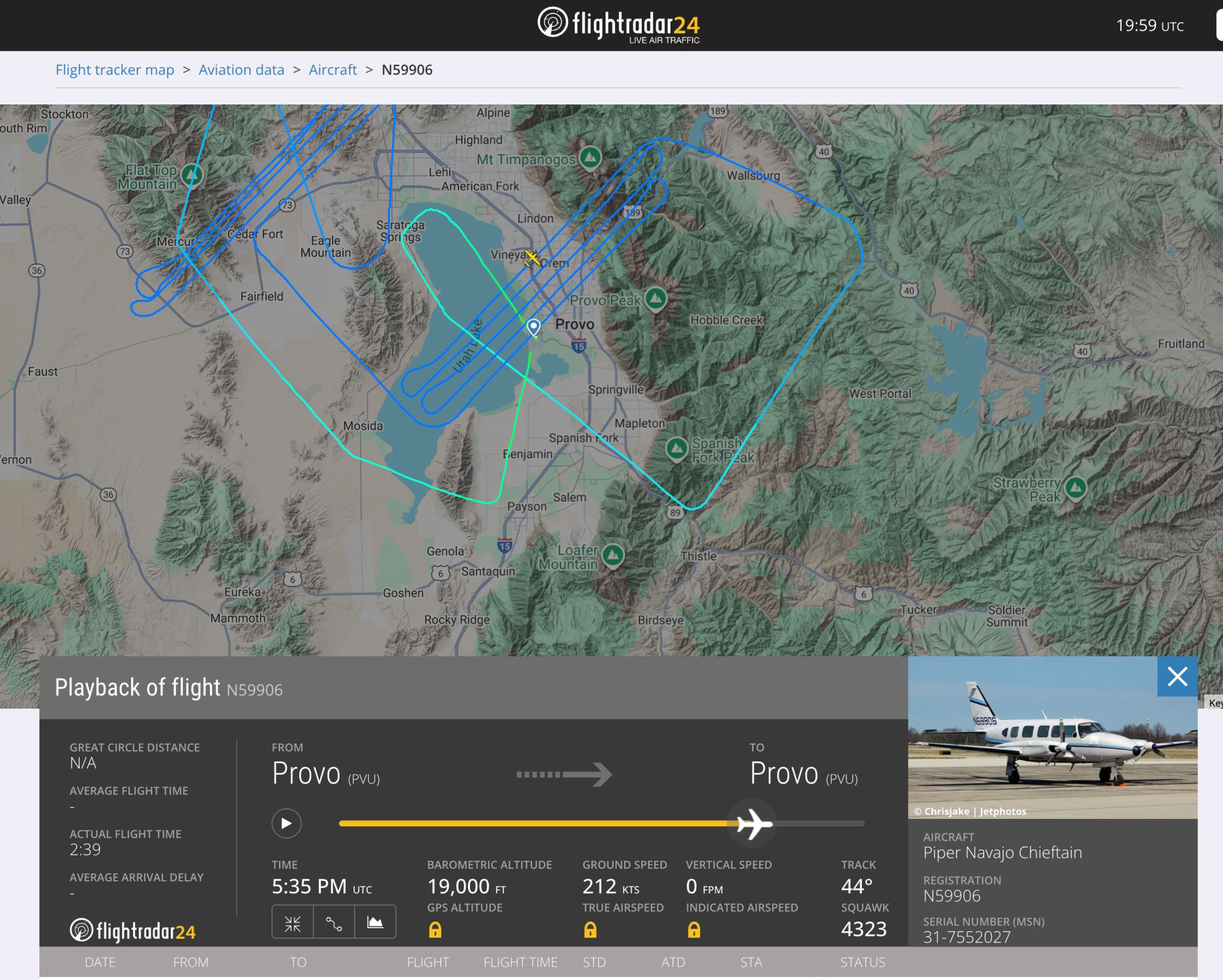
A second, independent capture — this one from Flightradar24, shared by John Cullen on X — shows the same day's flight as a completed playback rather than a live track. Its readings:
| Field | Value |
|---|---|
| Playback of flight | N59906 |
| From → To | Provo (PVU) → Provo (PVU) |
| Great circle distance | N/A (closed loop) |
| Actual flight time | 2:39 |
| Playback cursor time | 5:35 PM UTC |
| Barometric altitude at cursor | 19,000 ft |
| Ground speed at cursor | 212 kts |
| Vertical speed | 0 ft/min |
| Track | 44° |
| Squawk | 4323 |
| Aircraft | Piper Navajo Chieftain |
| Registration | N59906 |
| Serial number (MSN) | 31-7552027 |
| Photo credit on the type image | © ChrisJake / JetPhotos |
Several of these are new to this page and each carries weight:
- A 2-hour-39-minute round trip out of and back into Provo. That is a long time aloft for five passes lasting four to six minutes each, which means the great majority of the sortie was spent somewhere other than directly over the UVU campus. The map in the same capture bears this out — it shows a tight parallel-line grid over Utah Lake and the adjacent land, plus a second, larger and more irregular loop running north toward Flat Top Mountain and south past Salem. That is a survey block, and UVU sits on its edge.
- Squawk 4323 is a discrete transponder code assigned by ATC. It is not 1200 (VFR), not 7500/7600/7700 (emergency), and not a military or restricted block. A discrete code means the aircraft was in contact with and being worked by air traffic control for the flight — the opposite of a covert profile.
- 19,000 ft barometric at 212 kts. Provo field elevation is roughly 4,500 ft, so 19,000 ft MSL is about 14,500 ft above ground level — consistent with the high-altitude mapping band described elsewhere on this page and flatly inconsistent with the "low pass over the crowd" framing that some posts implied.
- MSN 31-7552027 confirms the airframe identity independently of the registration, which matters given the "registration is in question" claim discussed below.
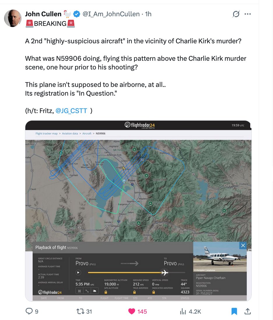
John Cullen's October 23 post and the "registration in question" claim
The Flightradar24 capture above was published by John Cullen (@I_Am_JohnCullen) under a 🚨 BREAKING 🚨 header, credited "(h/t: Fritz, @JG_CSTT)" — i.e. sourced to Crowdsource The Truth. His text, quoted in full:
A 2nd "highly-suspicious aircraft" in the vicinity of Charlie Kirk's murder?
What was N59906 doing, flying this pattern above the Charlie Kirk murder scene, one hour prior to his shooting?
This plane isn't supposed to be airborne, at all.. Its registration is "In Question."
The last line is a specific, checkable allegation and it should be read narrowly. "In Question" is an actual FAA registry status, not a rhetorical flourish: the FAA applies it when the agency has reason to doubt the eligibility or validity of a registration — for example, an unresolved ownership transfer, a suspect trust arrangement, or a re-registration lapse. An aircraft whose registration is "In Question" is not automatically prohibited from flying, and the status is common enough that it is a poor foundation for an inference about a specific sortie. But if the status is real for this tail, it is a public record and it is settleable — which makes it one of the better leads on this page precisely because it can be checked rather than argued.
Neither Cullen nor the source thread published the FAA registry screenshot backing the claim. Until that is produced, treat "registration in question" as unverified.
MARC Inc.'s published fleet and sensor list
A companion video compiled by @ProjectConstitu (Project Constitution) walks through screenshots of MARC Inc.'s own website. The navigation bar shown reads Home · Our Aircraft · Sensors · Our Pilots · Maintenance · Contact Us — the site of a working survey operator, publicly advertising exactly the capability at issue. The slides captured in that video add two facts not previously on this page:
- The fleet is described as a Piper Navajo alongside a Swearingen Merlin III — a spec-comparison slide sets the two types side by side. The Merlin III is a pressurised turboprop; the Navajo is the piston twin flown on September 10.
- The published client list names federal, state, and foreign governments among its customers. That "foreign governments" line is the one investigators seized on. It is, however, unremarkable for an aerial-mapping contractor — foreign mapping ministries and resource agencies routinely buy survey flights — and it says nothing about who bought this one.
The same video's sensor slide shows a grid of aerial camera bodies and LiDAR units, consistent with the payload list already described on this page. The title card the compiler placed over the flight map reads: "Apparent Aerial Surveillance Contractor Flights over Utah Valley University Just Prior to the Charlie Kirk Shooting." Note the word apparent — the compiler's own framing is conditional, and this page carries it at that strength.
Provenance of the aerial imagery in circulation
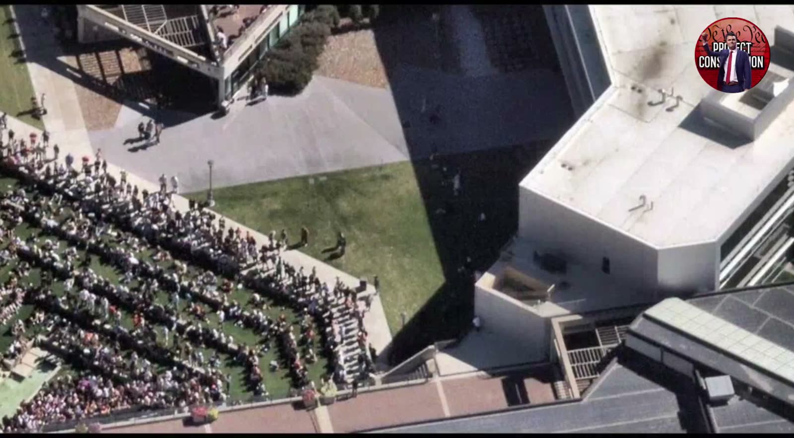
The high-altitude campus footage that circulates alongside the N59906 story — top-down views of the UVU amphitheatre with the crowd seated in curved rows, the plazas, the parking lots, and the adjacent residential streets — carries a persistent TikTok watermark reading @universehop00 in the lower centre of frame. In a separate recorded conversation, a Project Constitution guest credits the release to "Universe Hope 00 on TikTok and Eric Rosenwald on Twitter" — placing the same two names behind both the imagery and the annotated flight map.
That matters for weighing the material: the flight-track analysis and the aerial imagery are not independent corroboration of each other. They come from the same two-person pipeline. A reader treating "the map plus the pictures" as two sources agreeing is double-counting one source.
The imagery itself has never been forensically tied to N59906. No metadata has been published, no chain of custody has been shown, and the visible content — a wide-area campus view in bright midday sun — is consistent with drone footage, with mapping-aircraft imagery, or with commercial satellite/3D-map renders. Some frames circulating in the same set are demonstrably Google Earth-style 3D renders rather than photographs at all: one shows a blue teardrop map pin dropped on the campus, and another shows a media-player scrub bar reading 1:13 / 1:48. Those are screen recordings of mapping software, not aircraft imagery, and their presence in the same reel is a caution about the whole set.
Registration change since the event
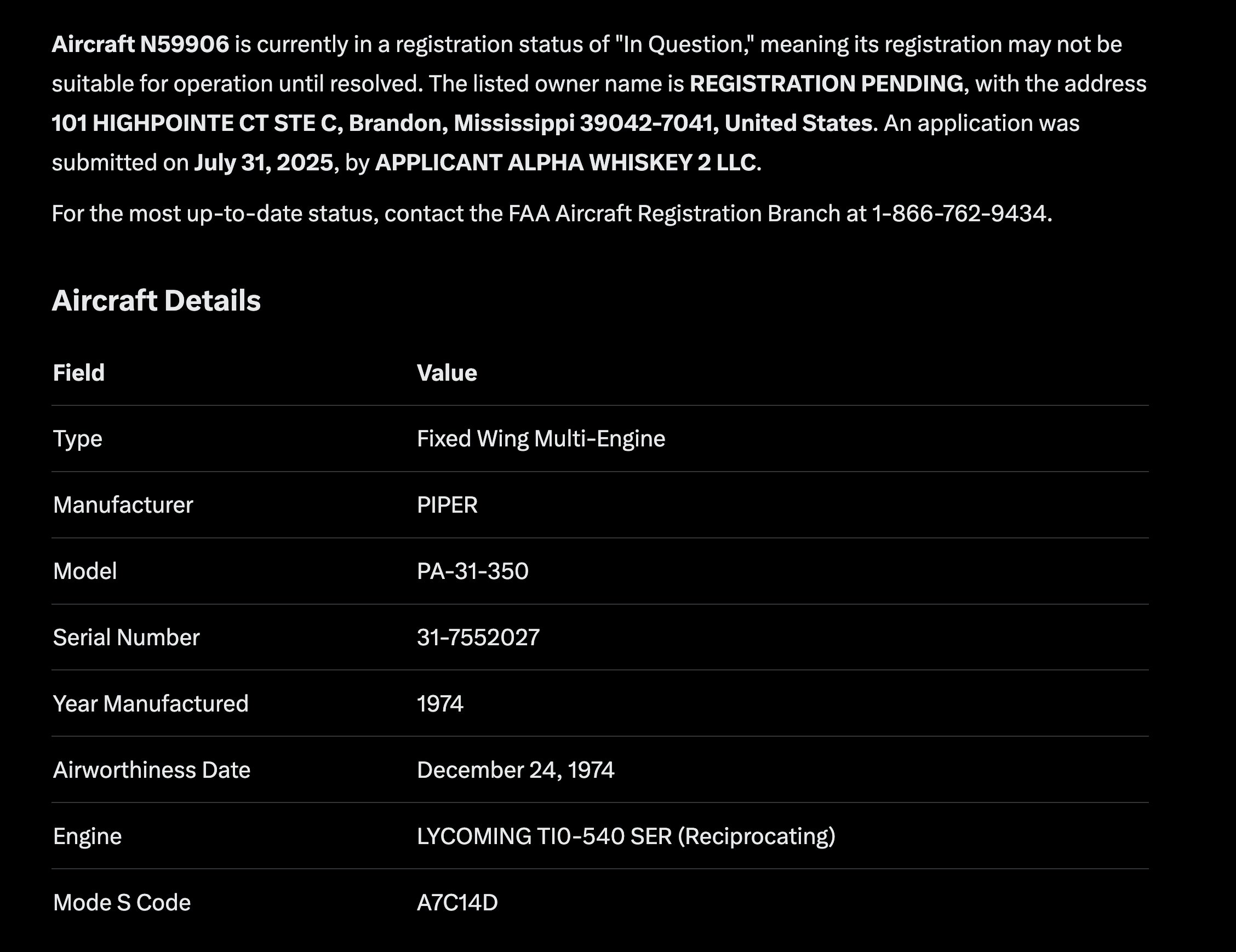
The FAA registry no longer shows this aircraft registered to MARC Inc. As of a certificate issued 4 April 2026, N59906 is registered to Alpha Whiskey 2 LLC of Brandon, Mississippi.
Two things are worth noting and neither is an accusation. MARC Inc. remains a large operator — the registry shows it holding 32 aircraft at Bolton, Mississippi, the majority of them PA-31-350 Navajo Chieftains, which is exactly the fleet profile of a working aerial-survey contractor and supports the survey explanation for the UVU passes rather than undercutting it. And MARC also holds an aircraft registered at Brandon, Mississippi — the same town as the new registrant — so the transfer may be an internal or local one rather than an arm's-length sale.
A single aircraft changing hands seven months after the event is unremarkable on its own. It is recorded here so the current registry state matches what this page says.
What this aircraft would cost to buy new today
- Type (FAA-confirmed): Piper PA-31-350 (Navajo Chieftain), built 1974, serial 31-7552027
- Registered owner: ALPHA WHISKEY 2 LLC (Brandon MS)
- Still built today? No — PA-31 built 1967-1984
- Priced against: Beechcraft Baron G58
- Cost to buy new today: ~$1.5 million
Navajo Chieftain out of production since 1984. No modern cabin-class piston twin fills the same slot; the Baron G58 ($1.5M) is the closest new piston twin. A new King Air 360 ($8.4M) is the closest turbine equivalent by mission.
List price is for a green airframe — interior completion, avionics options and any mission equipment are extra, and fleet buyers do not pay list. The full table for all 33 priced airframes in this investigation, with the method behind each figure, is on Aircraft Costs.
Flight data recovery
This aircraft is well covered and nothing about its record is missing. It is also the only tail in this investigation whose FlightRadar24 page still shows a populated flight table to a logged-out visitor — a working survey aircraft flies most days, so the free tier's seven-day window is never empty for it.
| Source | What it holds for N59906 |
|---|---|
adsb.lol globe_history | 9 days, 1 Sep 2025 – 8 Oct 2025 |
| globe.airplanes.live | 26 days, 1 Sep 2025 – 31 May 2026 |
| ADS-B Exchange monthly sample | 23 days, 1 Feb 2022 – 1 Jul 2026 |
| FlightRadar24 page | HTTP 200 in a browser on 24 August 2026, identity block intact — PA31 · Mode S A7C14D. 110 history rows on the free seven-day tier; older history paywalled. |
| Internet Archive | 4 page snapshots held (two FlightAware, two FlightRadar24, all Aug–Sep 2022); 0 flight rows recovered off them — the archived FR24 tables are empty. |
Removed from: nothing. No tracking site was found to have removed this aircraft's page. Our scripted probe recorded HTTP 403 from FlightRadar24, RadarBox and Planespotters, and those 403s are robot blocks rather than removals — five unrelated control aircraft got the identical 403 from the identical script, and all of them load normally in a browser. See What A 403 Actually Means.
Raw files: site/docs/Planes/N59906/data/recovered/ — the source is in every filename, and each
file has a .meta.json sidecar recording source, URL, HTTP status, bytes and date.
Fleet-wide: Flight Data Recovery · Per-Aircraft Recovery Status
Interesting In This Area
- Four mapping passes over campus are reported hours before the shooting window.
- A Navajo fitted for camera and LiDAR work is not an ISR jet.
- Do not confuse this tail with N55906, a different aircraft entirely.
- What it photographed remains unconfirmed, like most thin tails here.
Interesting In Other Areas
- UVU security says there were no drones that day.
- Campus security gaps are catalogued on the university side.
- UVU surveillance cameras cover the ground version of the same question.
- A man in all black was reportedly met by a construction worker.
Other Pages In This Section
A Special Air Mission callsign that surfaces in pre-event route tracking through Andrews, Nashville and Colorado Springs. It is tied to no confirmed tail in the case notes, which is why it is catalogued rather than argued.
Read thisOne of the five Egyptian-registered jets in the Provo cluster, with almost no standalone reporting behind it. John Cullen's maintenance-contract explanation is set out beside the shadowing reading.
Read this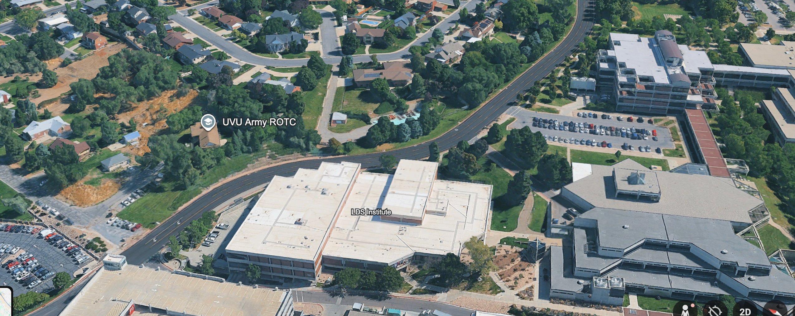
The Army ISR jet that flew near campus did not lift off from a civilian executive terminal. It reportedly departed an active Army airfield at Fort Bliss, and that military origin is the detail investigators keep returning to.
Read thisElsewhere In The Investigation
Six campus officers, perimeter duty, and no security drone — that is the documented deployment for September 10. The university runs its own drone program; it was not used to protect the event.
Read thisUVU Campus Security Gaps on September 10
Staffing, rooftop access, law-enforcement coordination and the emergency alert that did not go out — the documented and alleged failures on the university side.
Read thisThe campus system is the backbone of the probable-cause affidavit — a first capture near 11:50 AM, a pause at the tunnel stairs, the Losee doors at 12:02. What it never captured is anything settling how Charlie Kirk was killed.
Read this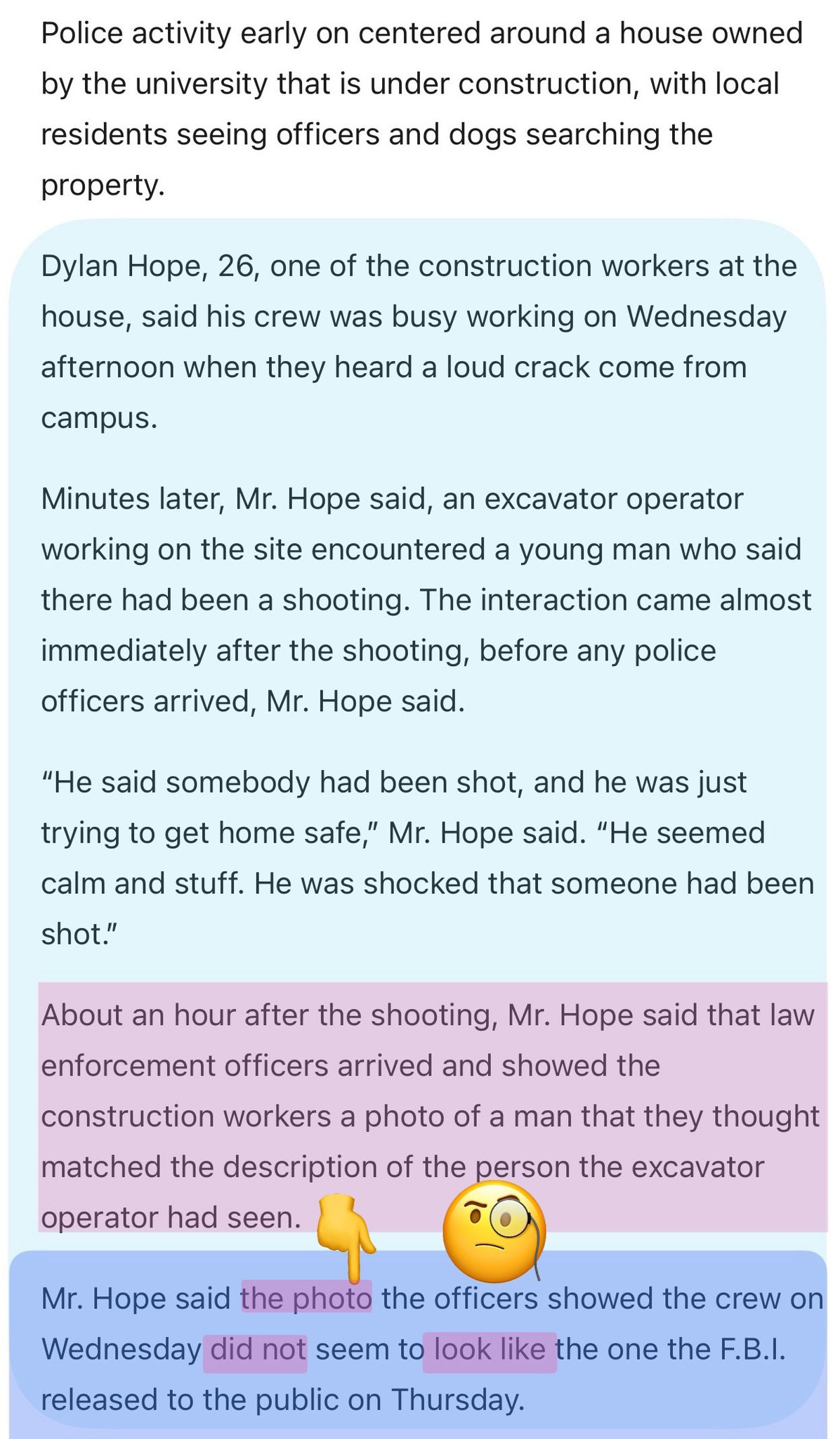
The All-Black Man the Construction Worker Met (Claims)
An electrician says a man in all black told the crew someone had been shot. The page rates its own evidence and states plainly that panic-moment eyewitness descriptions are among the weakest evidence there is.
Read thisSources
- OSINT analysis attributed to @rosenwald_eric, circulated by independent investigators on X.
- Public ADS-B flight-tracking history for tail N59906 (Provo Municipal Airport, PVU).
- Alleged leaked imagery posted by TikTok account @universehop00 (Oct 13, 2025) — unverified.
- Coverage and screenshots shared by independent researchers tracking aircraft around UVU.
- X threads alleging the Alpha Whiskey / Alexis Wilkins corporate link, posted by @ProjectConstitu, @AnaEscobarShow, @leahfiles, @Mini_111111, and @StefaniWilcox8 — unproven; disputed in the same threads.
- Rebuttal responses in those threads, including Grok, stating no public evidence connects the LLCs, Alexis Wilkins, or Kash Patel to the flight or the event.
Laws (Charlie Kirk)
- Who contracted MARC Inc.'s Piper N59906, who paid, what sensors were aboard, how any imagery was delivered, and the identity of the customer organization are exactly the kinds of records the proposed Charlie Kirk Investigation Laws are designed to force into the open — facts that are not public today.
- The X accounts amplifying the Alpha Whiskey claim called for the same kind of disclosure: the full MARC Inc. flight records, who hired the aircraft, the passengers and crew aboard, and any transponder deactivation during the flight. Forced disclosure would either substantiate or put to rest the corporate-ownership allegations rather than leaving them to circulate unverified on social media.
Citizen Investigator Claims on X
(Aircraft OSINT and attributed claims — not findings that any pilot, passenger, or official ordered or carried out the assassination.)
- Citizen OSINT tracks N-numbers near TPUSA events, Provo FBO activity, and foreign VIP tails; flight logs ≠ intent.
- Competing tallies exist for “shadowing” Charlie vs Erika; debunk and counter-debunk cycles continue on X.
- This page’s focus (N59906 MARC Survey Plane) should be read with the Planes overview and Sept 10 flight timeline for cross-checks.
This website's author is @HolonCitizen on X and YouTube/@HolonCitizen. Follow me there.
Interesting
- Egyptian-registered jets reportedly tracked Erika Kirk's locations 73 separate times.
- No cell-tower ping timeline has been released, per the gun-drop questions.
- The ballistics index argues every link in the state's chain fails separately.
Related Areas
Related
Track This Aircraft
Research this aircraft's flight history yourself on both major flight-tracking sites. They differ in one important way:
- FlightRadar24 — N59906 — large commercial tracker that honors the FAA's LADD block list, so flights an owner or the government has asked to hide can be missing.
- ADS-B Exchange — N59906 — volunteer-fed, unfiltered tracker that does not honor LADD, so it often shows blocked aircraft and tracks the filtered sites leave out.
Images
Videos
Footage related to this page. Each card opens that clip's own page, with the video, the full write-up, and its source.