Tyler Robinson on September 10, 2025
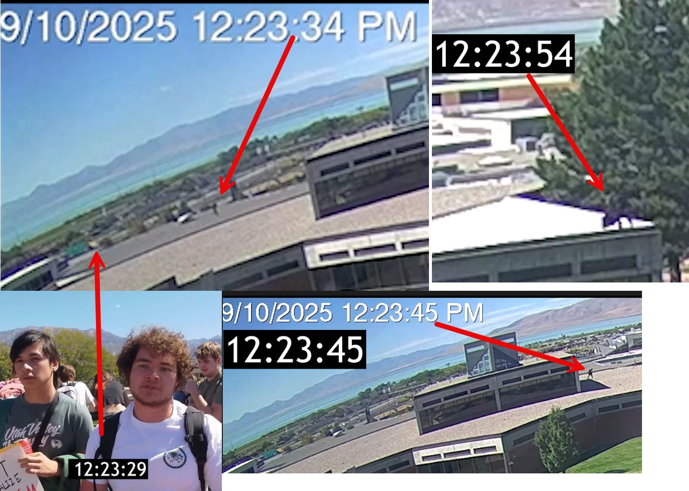
Surveillance camera stills from 9/10/2025 showing timestamps 12:23:29 through 12:23:54, mapping the path from the shooting position to the NE corner of Losee Center. Source: @GrayHuze on X, April 14, 2026.
This page examines Tyler Robinson's claimed movements on the day of the Charlie Kirk assassination, September 10, 2025, at Utah Valley University. The timeline raises questions about whether Robinson could have physically carried out the shooting and reached the locations shown on surveillance footage in the time documented.
Shooting Position to Losee Center: 25 Seconds
According to @GrayHuze (Gray Hughes Investigates), surveillance camera footage shows movement from the shooting position to the North East corner of the Losee Center building in 25 seconds.
The surveillance stills show four timestamps:
- 12:23:29 — A figure near the event area at ground level
- 12:23:34 — Rooftop/elevated camera showing movement with a traced path (red arrows)
- 12:23:45 — Aerial surveillance view of the Losee Center building corner
- 12:23:54 — Building-level camera showing arrival at the NE corner of Losee Center
A prior question sits underneath the stopwatch: the majority citizen finding is that Charlie Kirk was killed by an explosive device rather than a rifle round, which would make the entire rooftop-to-Losee traverse a movement with no shot attached to it.
This 25-second window is a key data point in evaluating whether the claimed shooter could have traversed from the alleged shooting position to the documented location on the Losee Center building.
Law Enforcement's Detailed Rooftop Timeline (as reported)
A minute-by-minute sequence compiled in Charlie_Kirk.txt from law-enforcement references and surveillance descriptions traces the movements attributed to the suspect. Each entry below is a reported observation, not an established fact against Robinson:
- 8:29 a.m. MT — Arrived on the UVU campus driving a gray Dodge Challenger, reportedly wearing a plain maroon T-shirt, light-colored shorts, light-colored shoes, and a black hat with a white logo. No backpack noted.
- 11:49 a.m. MT — Seen in a nearby neighborhood; a clothing change is reported to a black long-sleeve shirt with a U.S. flag and eagle, dark jeans, a dark hat, large sunglasses, and a dark-colored backpack.
- 11:50 a.m. MT — Walking north of Campus Drive near 800 West, reportedly with a limp (stiff right leg, slow pace).
- 11:52 a.m. MT — Tracked through stairwells up to the roof of the Losee Center (about 150 yards from the courtyard).
- 11:53 a.m. MT — Paused at the top of the stairs, reportedly pulled out a cell phone, then descended into a pedestrian tunnel and up a parking-garage stairwell.
- 12:02 p.m. MT — Walking on the north side of the Losee Center, still limping; entered through southeast-corner doors.
- 12:15 p.m. MT — Ascended to the roof, crossed a railing from a public walkway, ran across the roof, and reportedly crawled into a shooting position.
- 12:17 p.m. MT — Climbed over a short wall and crouched on the north side of the roof.
- 12:22 p.m. MT — Stood, ran west near the edge (the limp "no longer noticeable"), and lay down facing the courtyard, reportedly about 430 feet (130 m) away.
- 12:23 p.m. MT — A single shot is reported fired from the roof; 12:23:30 is cited as the exact moment of the shot to Kirk's neck.
- 12:24 p.m. MT — Reportedly placed a dark-colored item (a rifle wrapped in a dark towel) on the roof, lowered onto the grass, and ran north into a wooded area. A Mauser Model 98 .30-06 bolt-action rifle with scope was later recovered there; a shoe impression was described as consistent with Converse / Chuck Taylor sneakers.
The "limp no longer noticeable" detail and the reported change back into the morning maroon shirt and cap after the shooting are two of the points citizen investigators cite when questioning whether one person made all these movements (see Stairs Guy vs Tyler Robinson).
The Runner "Started Before the Shot" Claim
Charlie_Kirk.txt records an analysis arguing the rooftop figure began running before Kirk was struck, which the author frames as making the attributed shot "impossible":
- The claim states Utah County DA Jeffrey Gray and UVU are "hiding the rooftop-view video files," and that the released clip was "trimmed" to start at 12:23:34, when the runner was already about 60 feet from the perch position.
- Using a measured 220 feet in 15 seconds, the analysis back-calculates that the runner "began all-out run at 12:23:28," while "Charlie was hit at 12:23:30" — i.e., the figure was reportedly already fleeing at the moment of the shot.
This is a reported reconstruction by an online investigator, not a court finding; it is offered as an argument for releasing the full, untrimmed rooftop footage.
The 8:07 AM "Same Clothes" Photo (claim)
A separate claim in the master file, attributed to a bystander photographer and TMZ footage, holds that Robinson was photographed at 8:07 a.m. in a "plum" (maroon) shirt, dark shorts, and a black hat with a triangle logo, carrying a backpack — and was allegedly seen in the same clothes shortly after, which the source uses to argue "NO WAY he could have been on the ROOF" in the dark outfit. This is presented as a reported eyewitness claim requiring the underlying HD images to verify.
Day-of Timeline (Compiled from Multiple Sources)
Based on publicly discussed doorbell cameras, surveillance footage, and law enforcement references (see Surveillance Cameras for the breakdown by device — Ring, WYZE, UVU surveillance — and Tyler on Surveillance Cameras for the full sighting list):
- 8:07 AM — Walking on S 800 W toward campus (Ring camera)
- 8:23 AM — Driving on W 880 S (WYZE camera)
- 8:29 AM — Driving on campus (UVU surveillance)
- ~10:00 AM — (claim, unverified) Reported contact with TPUSA representatives on the campus quad, following a campus arrival the source places at 9:24 AM — a time that conflicts with the 8:29 AM arrival above. No employee named; see TPUSA and Tyler Robinson Chat
- 9:57 AM — Walking on W 880 S (WYZE camera)
- Outfit change reportedly occurred thereafter (to jeans and long sleeve shirt)
- 11:44 AM — Walking on W 800 S (Ring camera)
- 11:49 AM — Walking on S 800 W toward campus (Ring camera)
- 12:23 PM — Time of shot (some references cite 12:27 PM; first radio report cited as ~12:26 PM)
- 12:23:29–12:23:54 — 25-second movement from shooting position to NE corner of Losee Center (per @GrayHuze analysis)
- ~6:38 PM — Claimed sighting at a Dairy Queen in Orem (unverified)
Key Questions About the 25-Second Window
- Is 25 seconds physically sufficient to traverse from the alleged rooftop shooting position to the NE corner of Losee Center?
- What is the distance and route between these two points?
- Does the figure in the surveillance stills match Robinson's described clothing at this time?
- Were there any obstructions, doors, or elevation changes (stairs, ladders) along this path that would affect transit time?
- Has any independent analysis confirmed or disputed the 25-second claim?
Laws (Charlie Kirk)
- The full unedited UVU surveillance footage of the 25-second window and cell tower data placing Robinson's phone along the route and the doorbell and traffic camera originals are things that the Charlie Kirk Investigation Laws may result in powerful truths coming out that aren't out yet.
Day-Of Claims Amplified on X
September 10 movement claims remain the spine of both prosecution and skeptic timelines:
- Campus presence, clothing changes, Chick-fil-A / TPUSA interaction claims appear in charging-adjacent reporting and skeptical "staging" threads alike.
- Acoustic multi-boom claims (@jonaaronbray) and witness "pop" descriptions pull against a simple single-rifle-from-Losee story for some investigators.
- Losee rooftop screwdriver / gravel-impression witness notes (@Willdbuckley / Daily Caller, Jul 2026) stay in circulation.
Cross-link with Losee Center and pre-shooting warnings.
Best understanding of when this happened
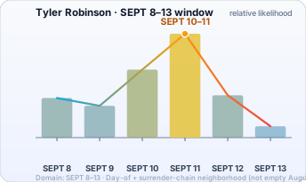
Best understanding: public Robinson timeline claims concentrate in SEPT 8–13, with heavy mass on day-of (SEPT 10) and surrender chain (SEPT 11). Chart is that week only.
Date range (working model): SEPT 8–13 · Day-of + surrender neighborhood
The chart below is not a government finding. Bar height is relative likelihood from public claims. Domain is trimmed to non-trivial likelihood.
Interesting In This Area
- The reported limp becomes no longer noticeable at 12:22 on the roof.
- Pack fullness runs the wrong way after an outfit change, per stair frames.
- A recovered Mauser is argued too long to carry in shorts.
- Testimony describes a rooftop change of clothes no camera recorded.
Interesting In Other Areas
- The roof timeline sets the crossing, the prone position and the drop.
- The Losee Center stands about 130 metres east of the courtyard.
- The shot time is disputed between 12:23 and 12:27.
- A downward rooftop angle argues against the reported neck path.
Images
Other Pages In This Section
Tyler Robinson Weapon and Rifle
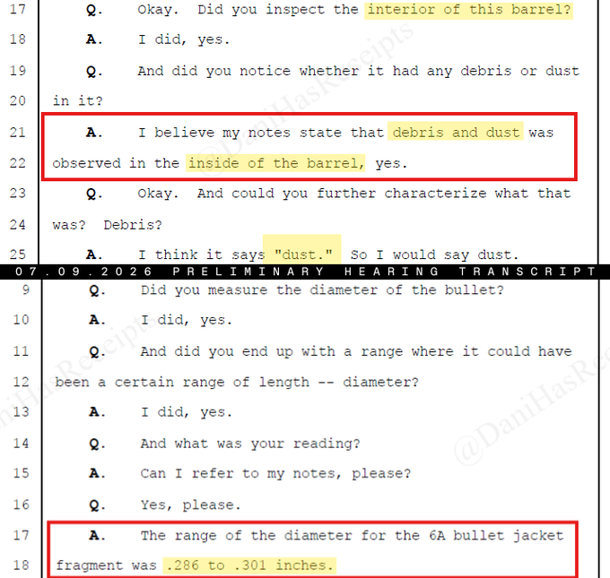
Everything the record says about the Mauser attributed to Robinson — recovery, DNA claims, the inconclusive ATF comparison, and the preliminary-hearing testimony about what was found inside the barrel.
Read this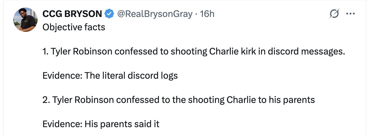
The 'Literal Discord Logs' Claim
An X post lists the confession as objective fact and sources it to the literal Discord logs. No member of the public has ever seen a Discord log in this case.
Read this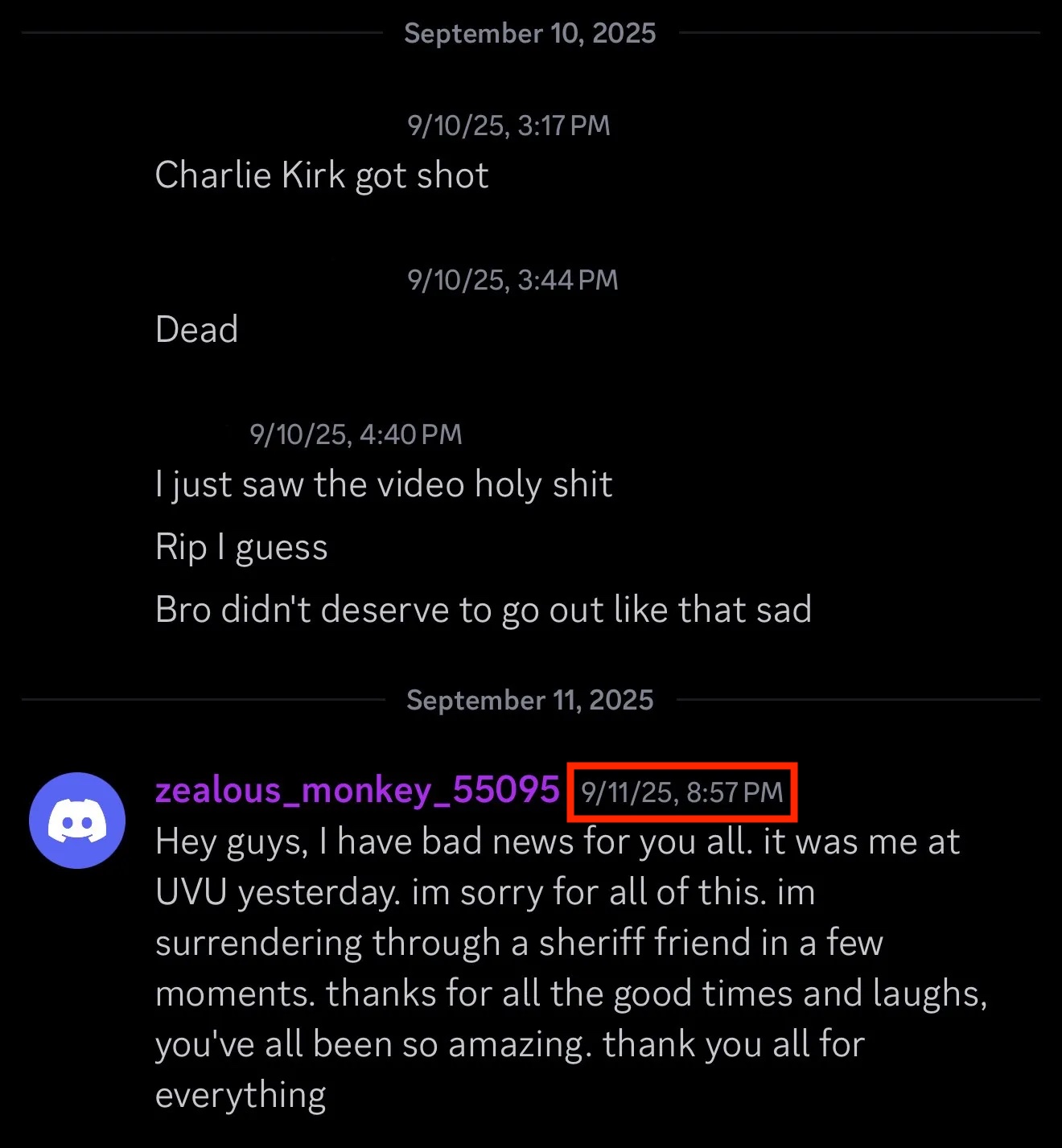
Tyler Robinson's Discord Friends, Servers and Handles
Every handle in the source material, reassembled after the warrant redacted the rest. Three servers, two men, six years of archive — and no country anyone can verify.
Read this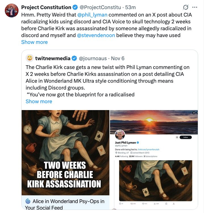
Phil Lyman and a Discord-Radicalization Post, Two Weeks Before
A Utah legislator engaged with a post about Discord radicalization two weeks before September 10. What a coincidence of that shape can and cannot carry.
Read thisElsewhere In The Investigation
Roof Timeline — September 10, 2025
Every roof event in order: the morning approach, the railing crossing, the alleged assembly point, the prone position and the drop to the grass. Read it before judging any single frame.
Read this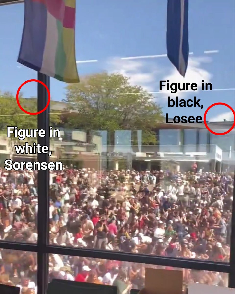
Losee Center (Alleged Sniper Rooftop)
The roof the government says the shot came from. Every part of it — line of sight, the lip, the drop, the screwdriver — has been measured by people who do not accept that account.
Read this
Shooting Time Disputes (12:23 vs 12:27 MDT)
12:23 or 12:27 — the two times circulate as if interchangeable. They are not: four minutes changes who was where, and every timeline on the site depends on which is right.
Read thisThe argument that a rooftop .30-06 cannot match the reported neck wound path, the energy, or the blood evidence. It is the single thread connecting almost every cause-of-death dispute on this site.
Read thisThis website's author is @HolonCitizen on X and YouTube/@HolonCitizen. Follow me there.
Interesting
- Coleman says the parents reject the confession, in the family denial page.
- No short-term listing was found for the Orem house — see its rental and listing history.
- A rare published negative result — zero hits anywhere — in the Debra Carlson name search.