Wooded Area Map — Rifle Recovery
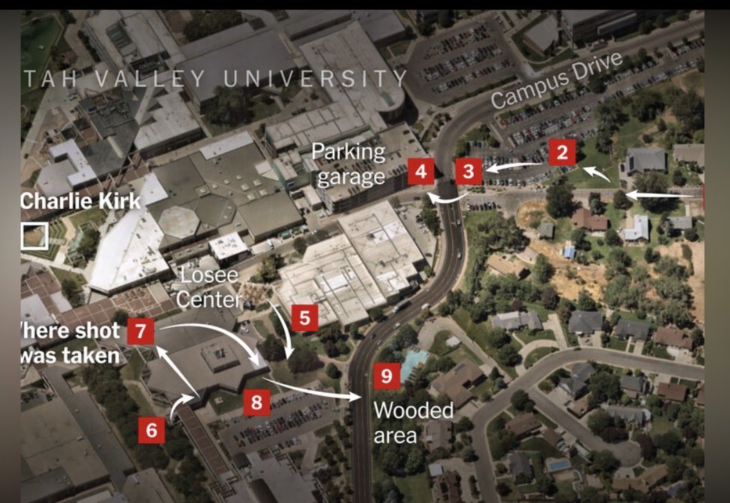
Annotated aerial map of the UVU campus and the residential block east of it. Markers 2–9 trace a movement sequence; marker 7 is labelled "Where shot was taken" and marker 9 "Wooded area." Source: @Mia_Stretch on X, June 29, 2026. Fallback gateway: dweb.link/ipfs/QmeC75N2hAYoTaVMu7Ac3B16pNAskkhmCLMPXja2J7UqDe
This page is about one map: the widely-circulated annotated aerial of the UVU campus that news outlets and citizen researchers both use to explain the September 10, 2025 event geography.
UVU's 158-page After-Action Report never once mentions the house UVU owns on the hill above the construction site, 691 W 925 S, even though the rooftop man's exit path ran right beside it and the rifle was found at the base of that hill. Who was in that house on September 10, and whose vehicles were parked in front, may be the single fastest way to crack open who really carried out Charlie Kirk's assassination. UVU holds the keys, the approvals, and the records, so we all need to ask UVU to release a "UVU House / Charlie Kirk Report".
What the map shows
The map is an overhead satellite view looking across the eastern edge of the campus, with red numbered markers and white arrows drawn on top. The legible labels are:
- "Charlie Kirk" with a marker box on the west side, at the courtyard where the event was held.
- "Where shot was taken" — marker 7, on the structure adjacent to the courtyard.
- Losee Center, Parking garage, and Campus Drive, which orient the rest of the sequence.
- Markers 6 and 8 on the roof and sidewalk immediately below it, and a long arrow east from 8 toward marker 9.
- "Wooded area" — marker 9, on the east side of the roadway, backing onto the residential block.
The sequence runs right to left and back again: markers 2, 3 and 4 come in from the residential streets and parking on the east, cross toward the parking garage, and continue to 5, then to the roof at 6/7, then down and east to the wooded strip at 9. That is the movement path used in the mainstream walkthrough of the case, not an alternative theory — the same numbered graphic appears in press coverage of the campus geography.
What the map is useful for is narrow but real: it shows that the wooded area at marker 9 is a short distance from the roof at marker 7, on the far side of a roadway, and that it backs directly onto residential lots rather than sitting deep in open country. Anything found there was found within a couple of minutes' walk of the shot position and within sight of houses.
What this settles and what it does not
Maps can rule geometries in or out. This one supports two modest conclusions: the rifle-recovery location was close to the shot position, and it was adjacent to occupied homes rather than isolated. Both are relevant to the standing question of how the weapon was not located during the earlier searches of that strip.
What the map cannot do is establish intent or sequence of custody. Tyler Robinson has been charged, not convicted. Cross-check this map against UVU Campus Maps, Possible Shooter Locations, and the Timeline before drawing anything from it.
This website's author is @HolonCitizen on X and YouTube/@HolonCitizen. Follow me there.
X.com posts:
Interesting
- The maps section tests whether the claimed routes are even physically possible in the time allotted.
- The protection firm reportedly traded under one name while legally registered as another.
- The jet N1098L is reportedly run by an ISR defense contractor.
Related Areas
- Ballistics and the weapon
- Evidence Tyler is not the shooter
- Possible distraction people
- Locations
- Court proceedings
- Timeline overview